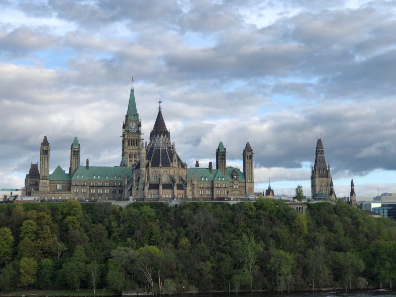
The Ottawa Parliament buildings seen from across the Ottawa River in the evening
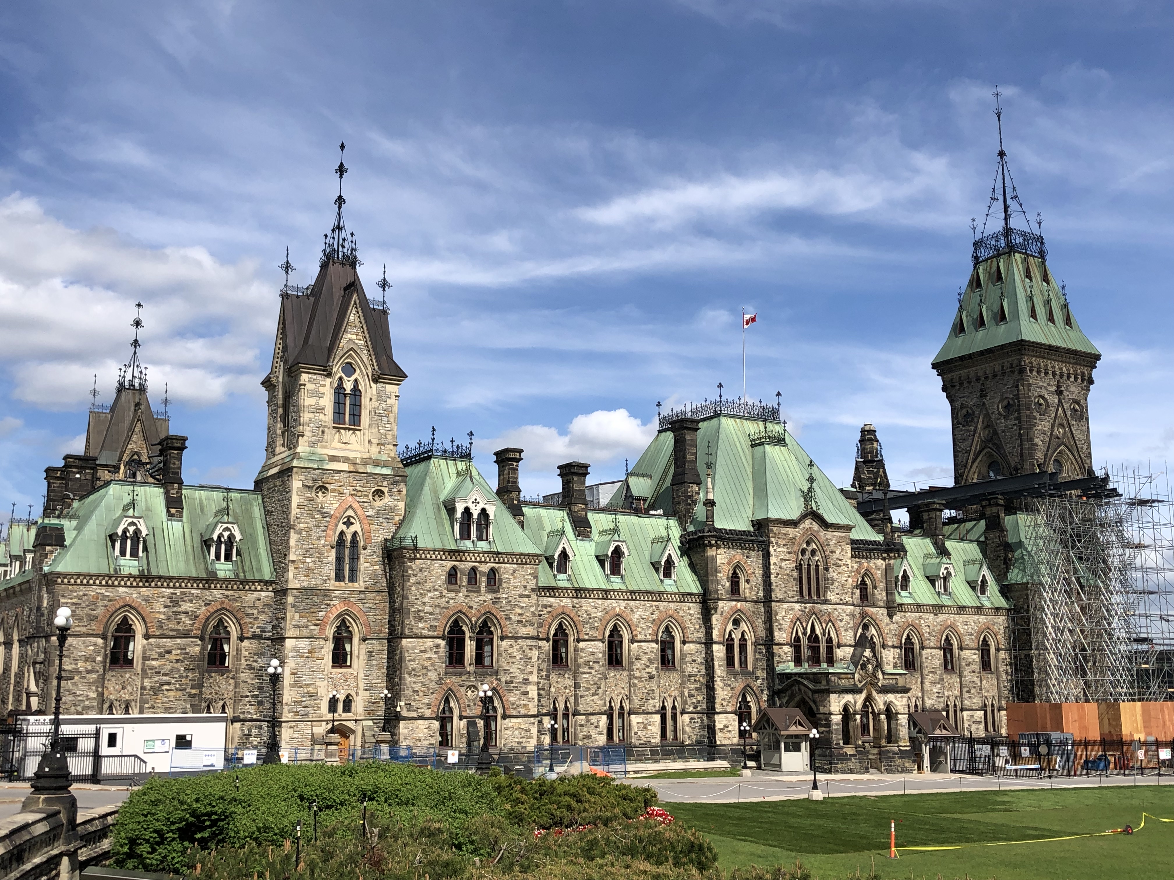
Being the capital of Canada, it goes without saying that Ottawa has plenty of government buildings. The city center also sits on an elevated hill off the shore of the Ottawa river, meaning that their main buildings could sit there and overlook everything. Because I had lots of work early in my trip and didn’t want to tire my legs out with tourism, I didn’t visit any before my race. However, the Friday before my race I did a quick warm up run to the shore of the Ottawa river and back. From there, I got lovely views of Parliament Hill, which you can see above. It features a huge clock tower, reminding me of Big Ben in London. It was flanked by the halls of parliament itself, wide brick buildings that were topped with green roofing. To be honest, I was a little surprised to not see any red, in the spirit of the country’s flag and maple leaves.
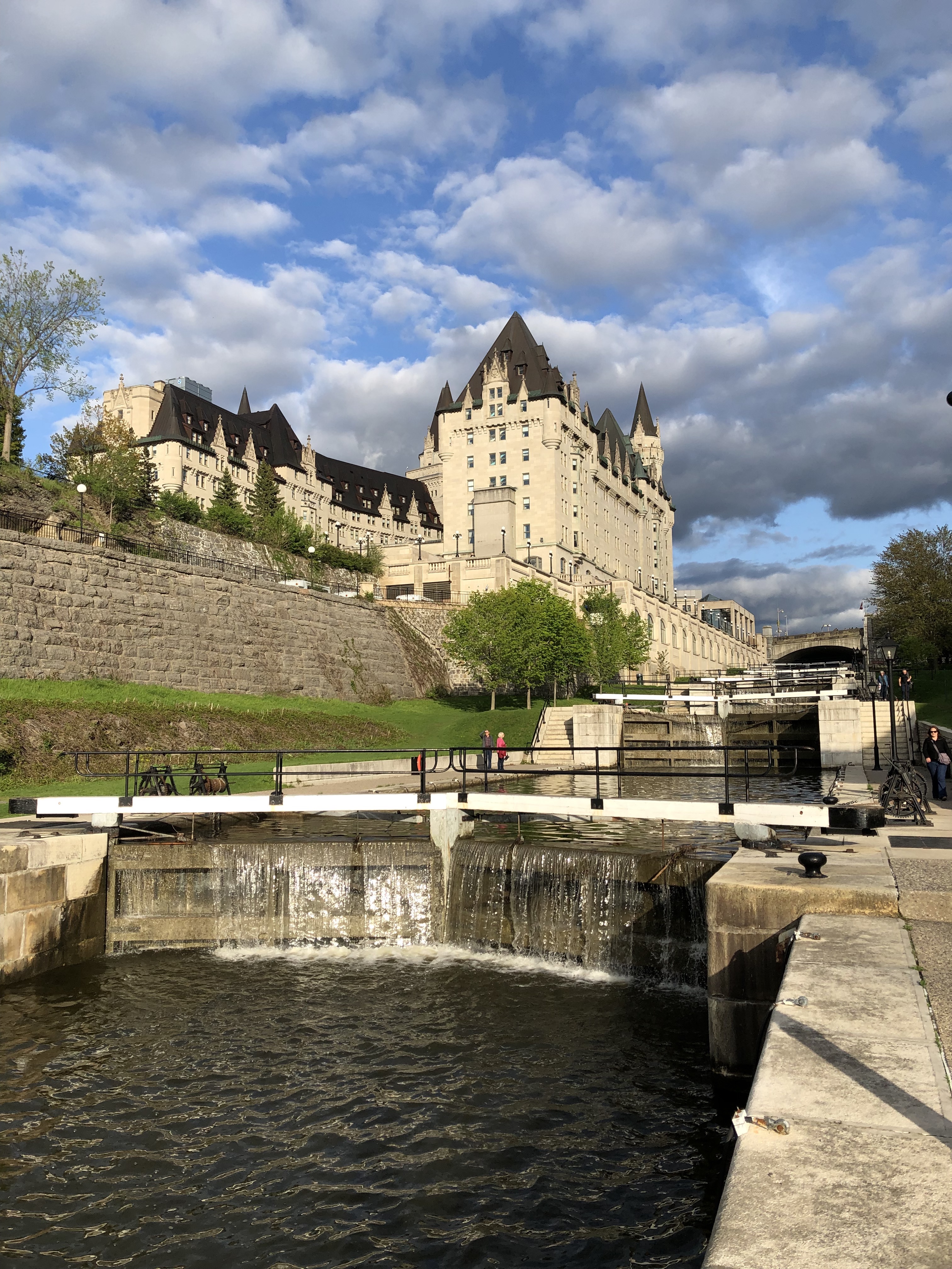
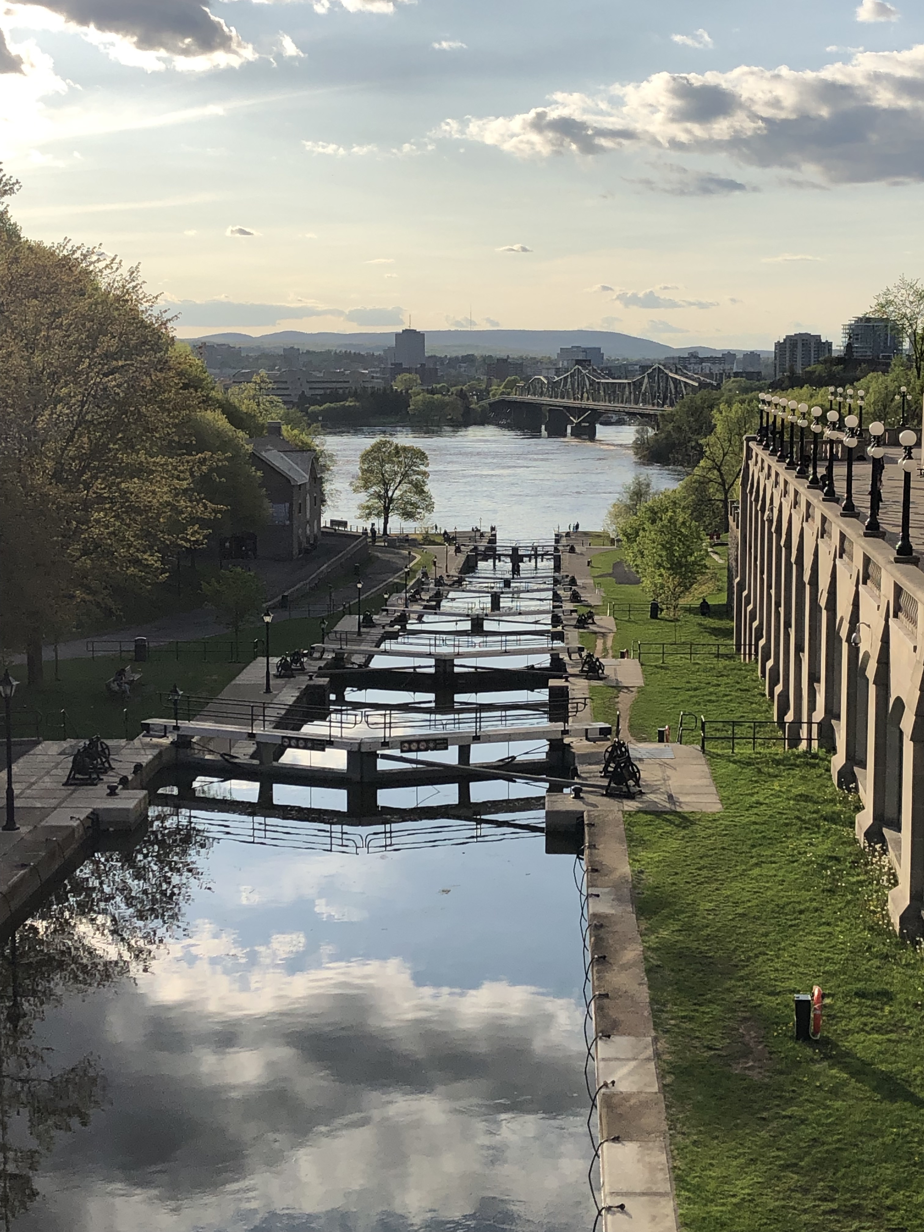
Along that run, I also saw a couple other lovely landmarks. The first was the Rideau canal, and the locks that ran down to the Ottawa river. It’s hardly used now, but the canal was instrumental in the town’s early days for transporting logs and other goods up the Rideau river south of the city. Most Canadian cities have a Fairmont chateau, a staple of the trans Canada railway companies that built across the nation in the late 1800s, and Ottawa’s sat overlooking the Rideau locks. It was the perfect location for such a regal hotel.
Ottawa’s Fairmont Chateau overlooking the Rideau Canal locks system A closer look at the locks themselves, which have mostly outlived their usefulness View from above the locks, as they cascade down towards the river The Alexandra Bridge which I took briefly to Gatineau, Quebec, and back
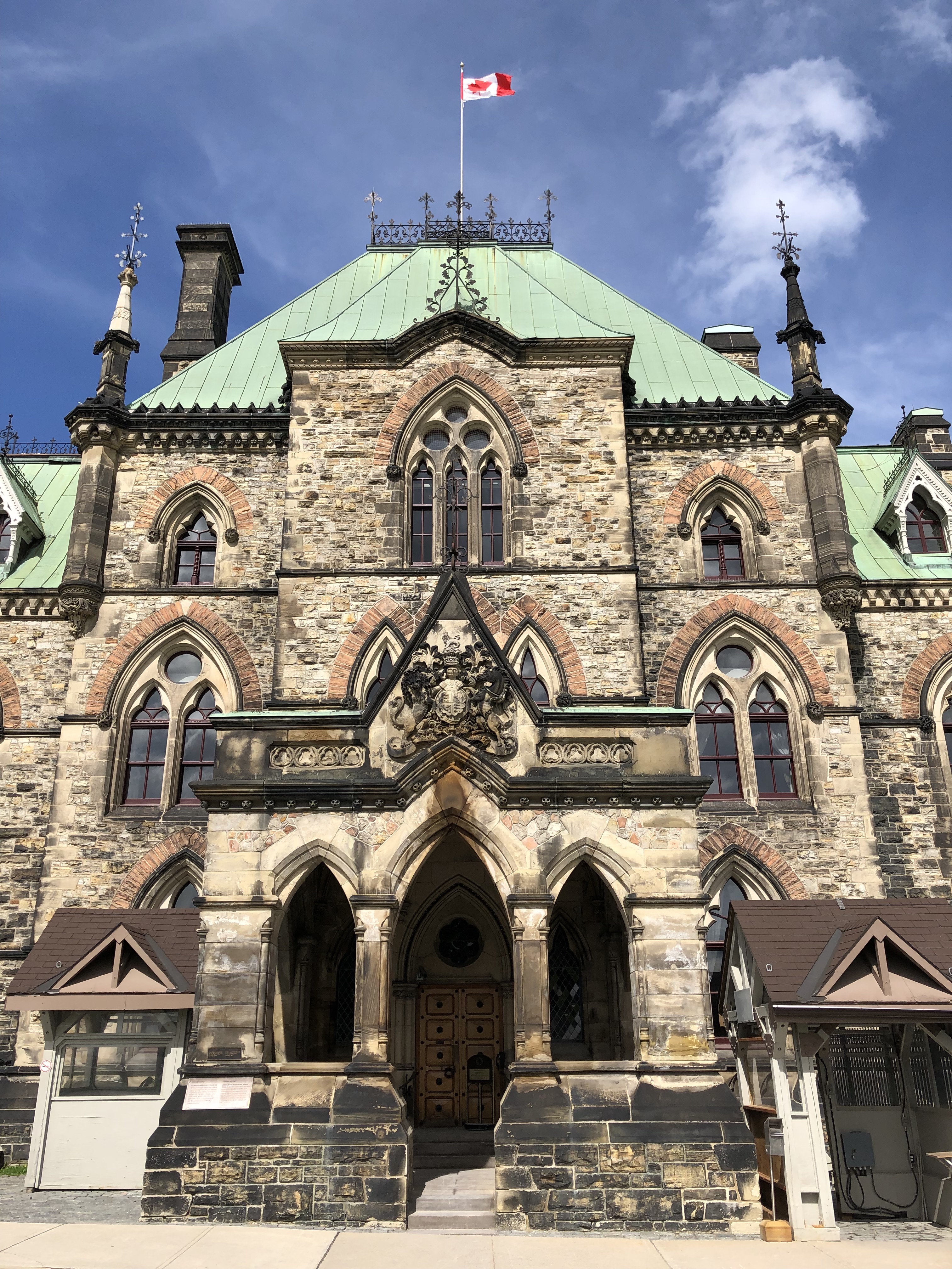
Once I had recovered enough from running my race, I hopped (or more honestly, limped), back into tourist mode. Ottawa allows visitors on timed tours into some of its buildings, and I was able to get a 4 p.m. tour through the parliament buildings. I finished my late lunch at Pure Kitchen on Elgin about an hour before the tour, but it took me nearly a half hour to amble over to Parliament Hill. Still, that left me with enough time to wander around and take pictures of some of the landmarks. One of the most striking were monuments to each of the wars that Canadian soldiers had fought in, notably the two World Wars and the Korean war. Upon closer look, it was more clear that the bricks of the parliament buildings were starting to blacken and be stained with soot. One by one, they were actually being renovated, and construction scaffolding was propped up on a couple buildings, the most noticeable of which was the base of the clock tower. There was an eternal flame memorial to commemorate the nation’s centennial anniversary in 1967, framed nicely in front of the clock tower. Before my tour, I had just enough time to stop by their Supreme Court building as well. Here’s what they looked like:
Ottawa’s memorial to Canadian soldiers who fought and died in the Great War An ancient building on parliament hill, with the soot on bricks starting to show its age Scaffolding surrounding the western wing of Ottawa’s parliament hall Ottawa’s centennial Eternal Flame, with the parliament’s clock tower in the background The Ottawa supreme court building, the last one I managed to hobble past
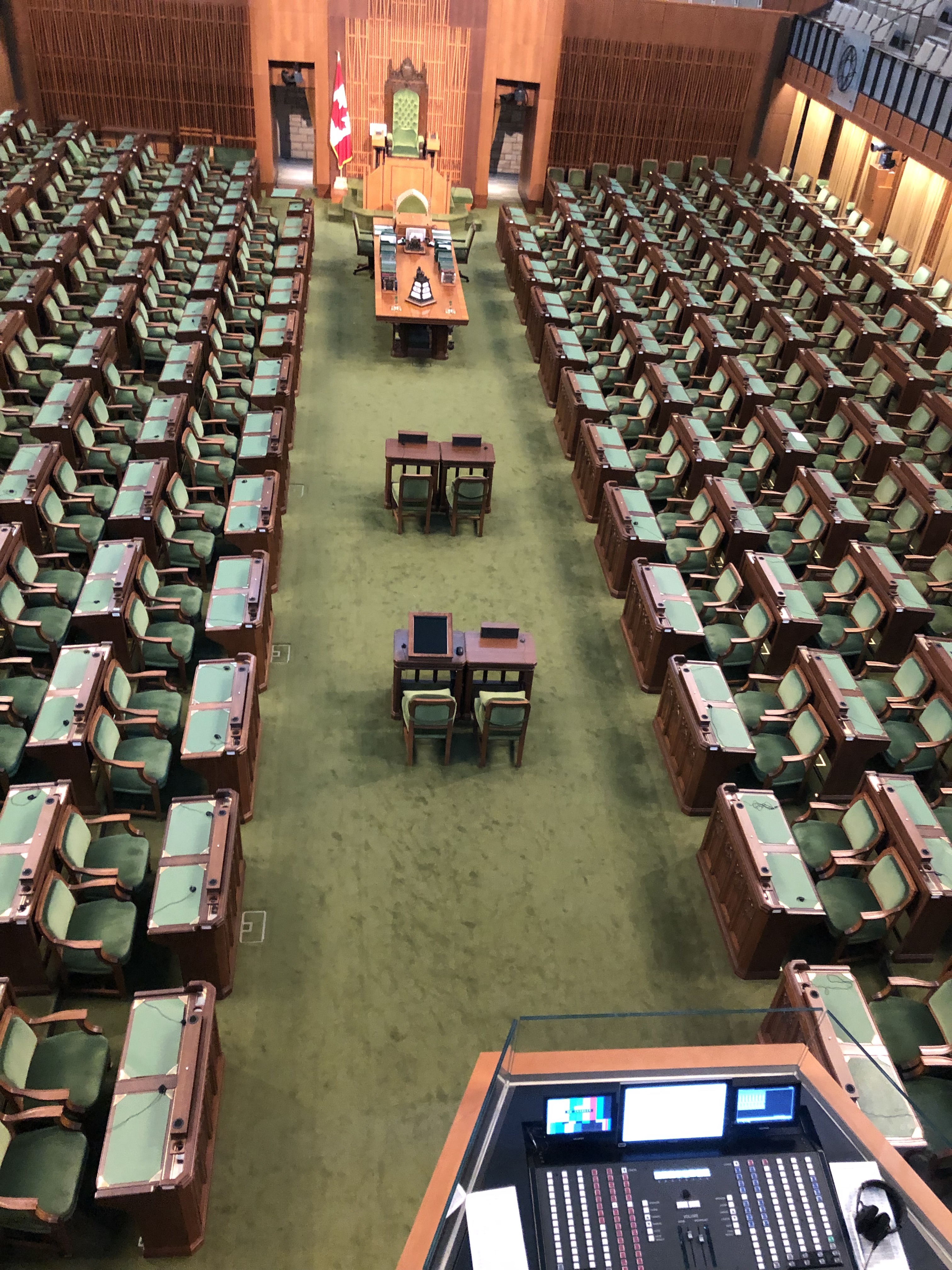
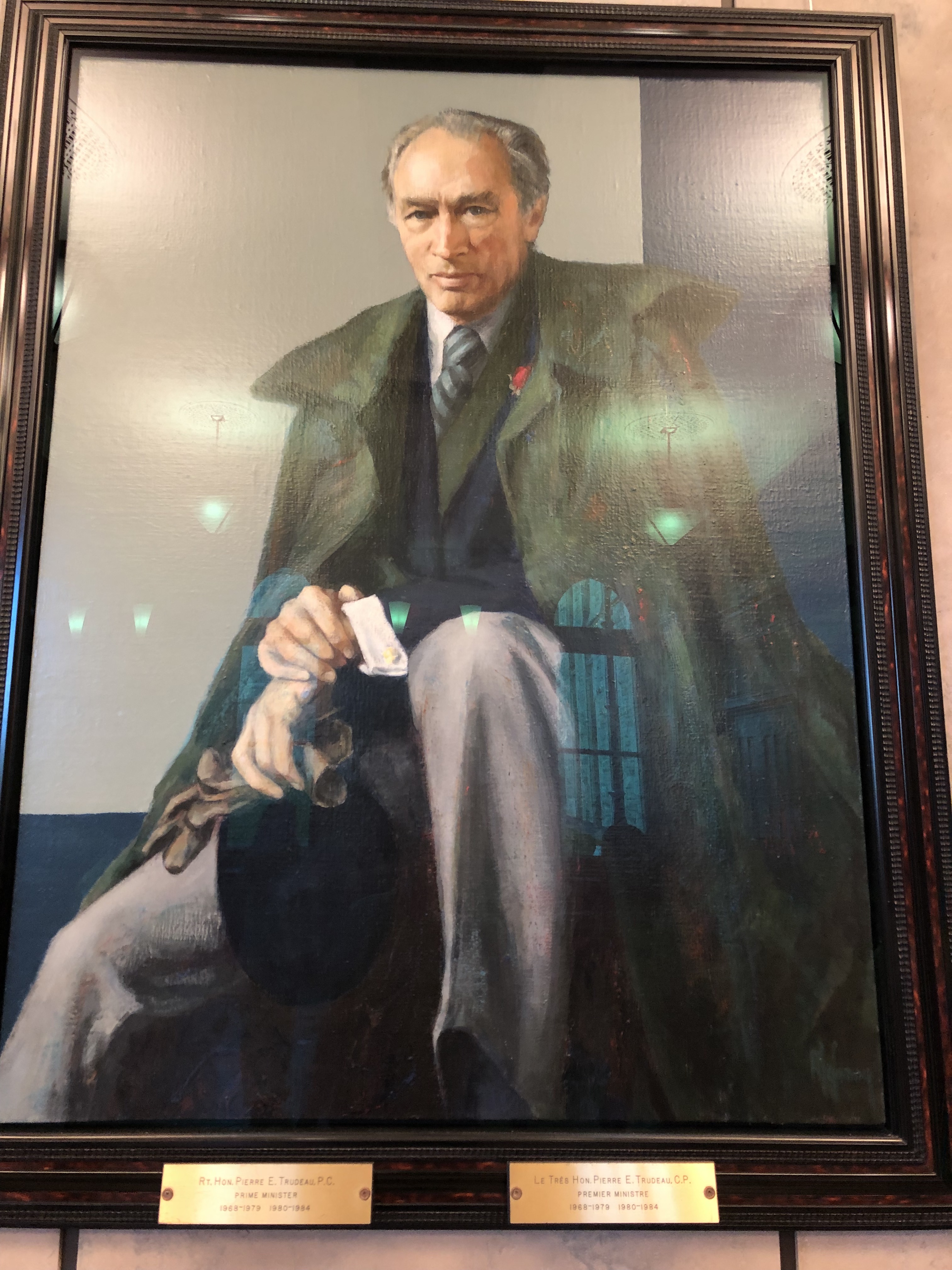
Right on time, I was able to enter the tour of Ottawa’s parliament building. It was led by a student from Montreal’s McGill University, who was on break from university. The official chambers were closed for renovation, so we were given a tour of the alternate buildings being used in their stead. The chamber itself is known as the House of Commons, the only name used now that something aristocratic like House of Lords has fallen out of fashion. The guide kept prefacing each politician’s name with “the right honourable”, which is apparently a custom there. It’s something I can’t imagine happening in the United States these days. Anyhow, another interesting custom she mentioned was the presence of a rifleman that was assigned to sit next to the Speaker of the House of Commons. It’s probably not necessary now, but in Canada’s early days the speaker was often charged with passing on unfavorable news to the British government. This meant that assassination attempts were frequent, hence the assigned guard. Lastly, portraits of various Canadian prime ministers lined a couple of the hallways. I recognized some of them because they had lent their names to airports, like Pierre Eliot Trudeau for Montreal’s airport, or Pearson for Toronto’s and Jean Lesange for Quebec City. Ottawa’s airport bears the Macdonald-Cartier name, two of the joint “founding fathers of Canada”. The chambers reminded me more of the Hungarian parliament than the United States capitol setup, in that it was more cozy and compact than that other chamber. The seats looked plenty comfortable enough to work in, and I suppose that’s the most important part.
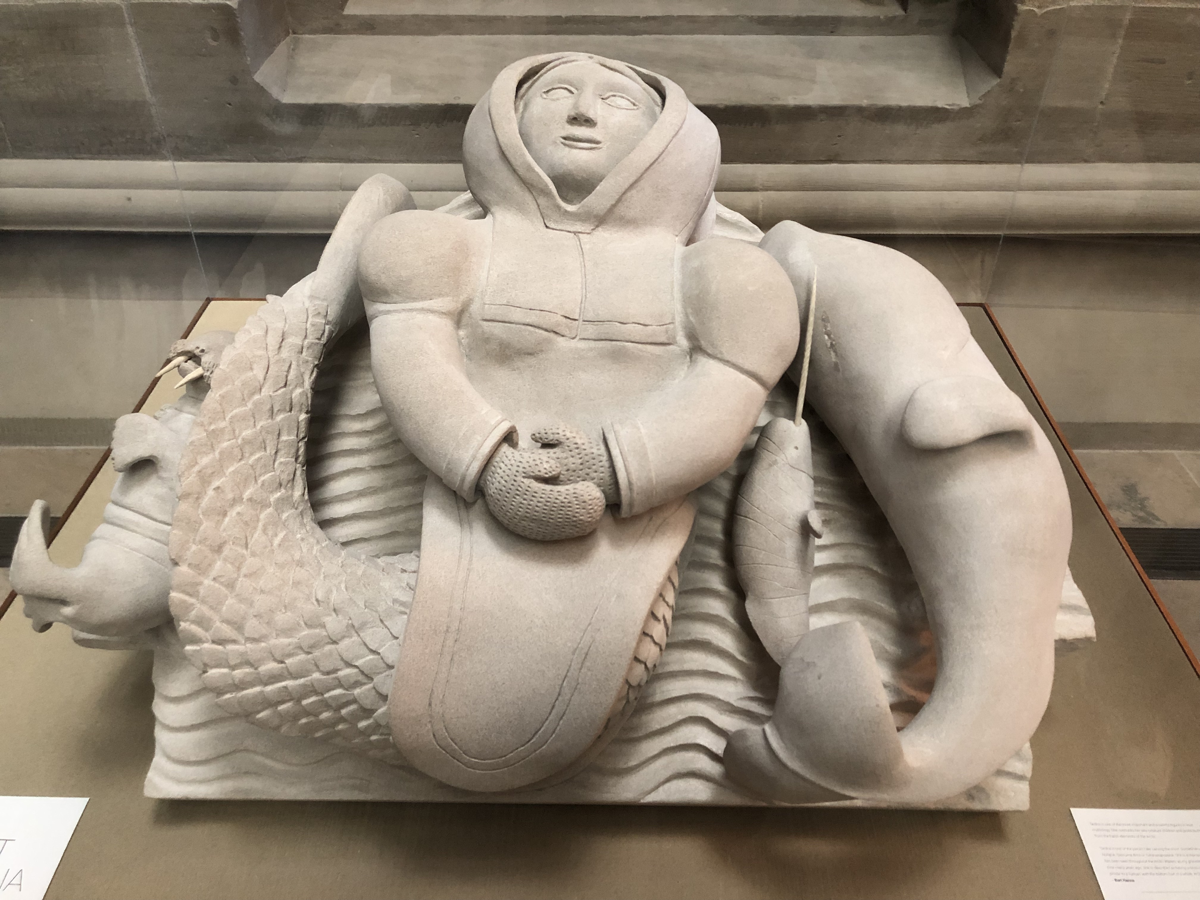
Chamber of the House of Commons in Ottawa, on Parliament Hill A statue in the halls of parliament that acknowledges the history of First Nations as well Prime Minister Pierre Eliot Trudeau (not to be confused with Justin), namesake of YUL airport One of the conference halls we passed through. Chairs look similar to my company’s chairs…
The next morning, I managed to snag entry for a Senate chamber tour at 10:15 a.m. Although I had the Memorial Day off in the states, it was business as usual for Ottawa on this Monday and I was left to myself in most of the places I visited today. After getting a kickstart with a cappuccino at Equator coffee, I made my way to the Senate building, just alongside the Rideau canal. Unlike the older Parliament buildings, the entrance to this one was high and vaulted, supported with Greek columns. The steel and glass windows above reminded me of a train terminal, something like New York’s Grand Central. This tour actually ended up being a good bit shorter than the parliament tour I had. The senate wasn’t in session today, so we were able to visit each of the chambers. We also witnessed a school group seated in the senate members’ usual chairs, something casual that I wouldn’t expect in our nation’s capitol but thought was cool to see here. Even the security guards at the front of the room seemed to enjoy watching the kids learn more about their nation’s government in the chambers themselves. Members’ names were still prefaced with “the right honourable”, establishing it as a trend to me. Lastly, the chamber doors had the emblems of each of the 10 Canadian provinces and 3 territories emblazoned on it. Props to anyone who can identify each one!
Cavernous entrance to Ottawa’s Senate buildings. Reminds me of a train station One of many senate conference rooms we got to see Senate… er… class… is in session today! Security guards can’t help but crack a smile watching these kids! Something about “Right Honourable”… Panel with all the province and territory emblems
So, are Ottawa’s government buildings worth a visit? I certainly found it interesting being able to visit the chambers of Canada’s seat of government with reservations just a day in advance. The Parliament Hill buildings are really impressive in their own right, and I actually like their layout more than even the United States capitol. Aside from the marathon, I can’t say it would’ve ever crossed my mind to come out here, and definitely not just to see these government buildings. From the west coast, you’d probably pair Ottawa with a trip to either Toronto or Montreal, which are each within an hour flight or a day’s bus or train ride. If you do, I’d encourage you to stay 2 or 3 days, and these buildings are definitely worth a visit during that timeframe. It’s much less visited than Washington D.C., but I think Ottawa can hold its own when it comes to having an impressive complex for their center of government!
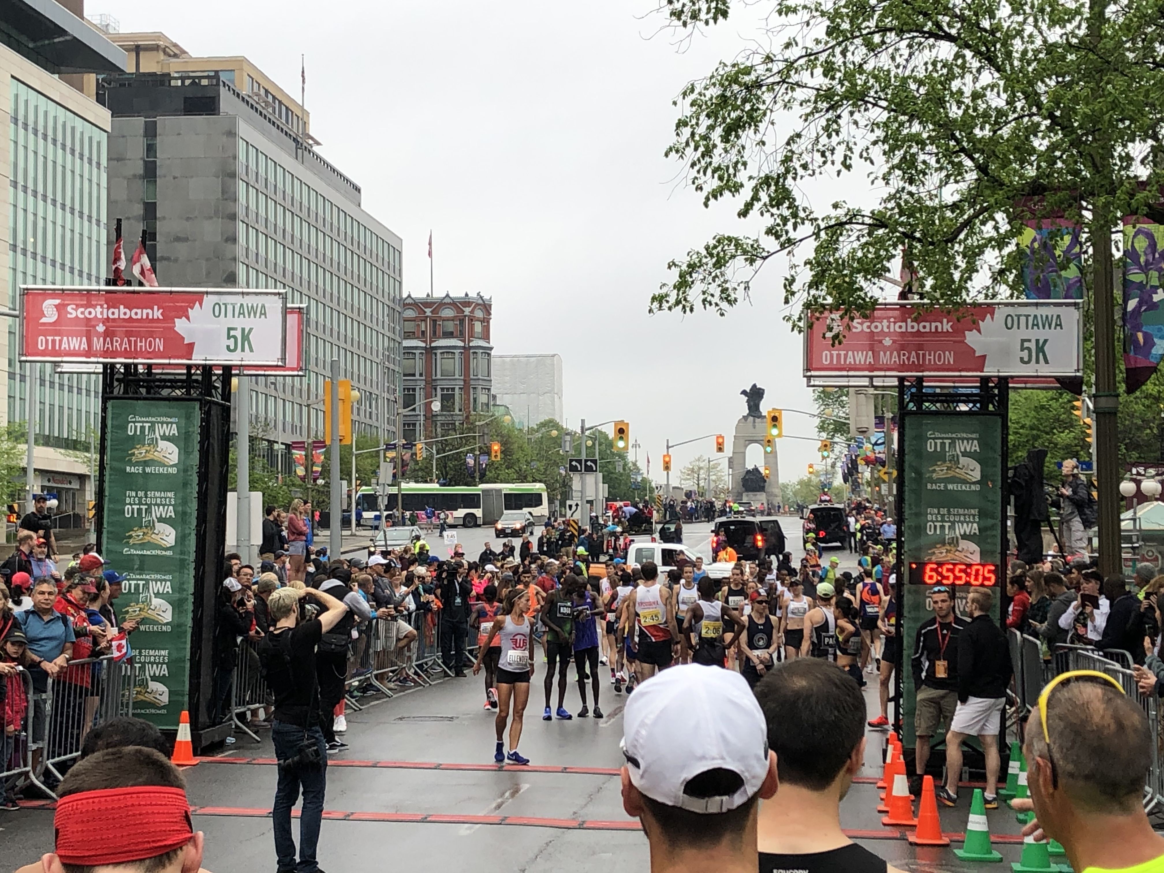
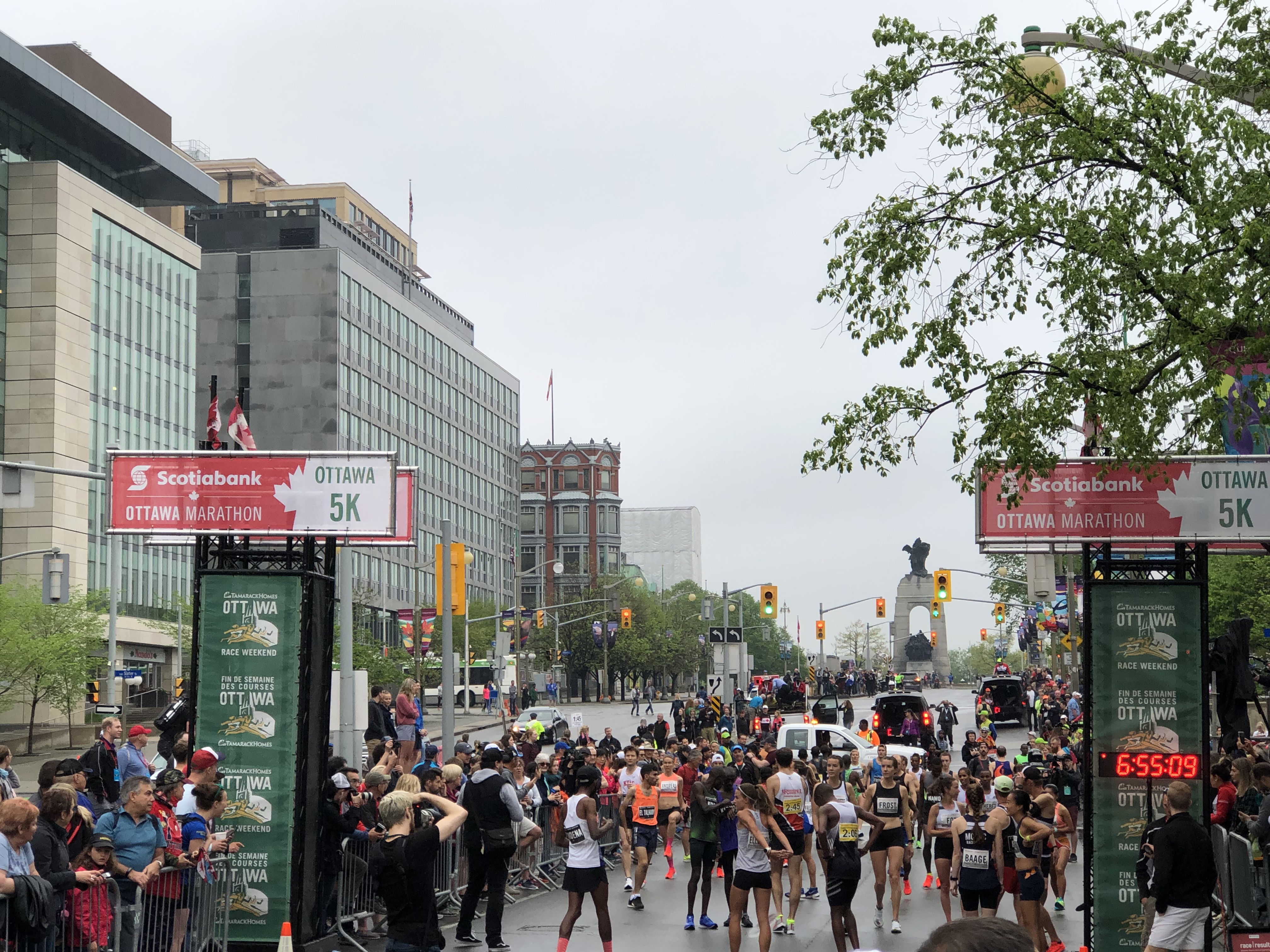
Just behind the elite field, 5 minutes ahead of the marathon itself at the starting line!
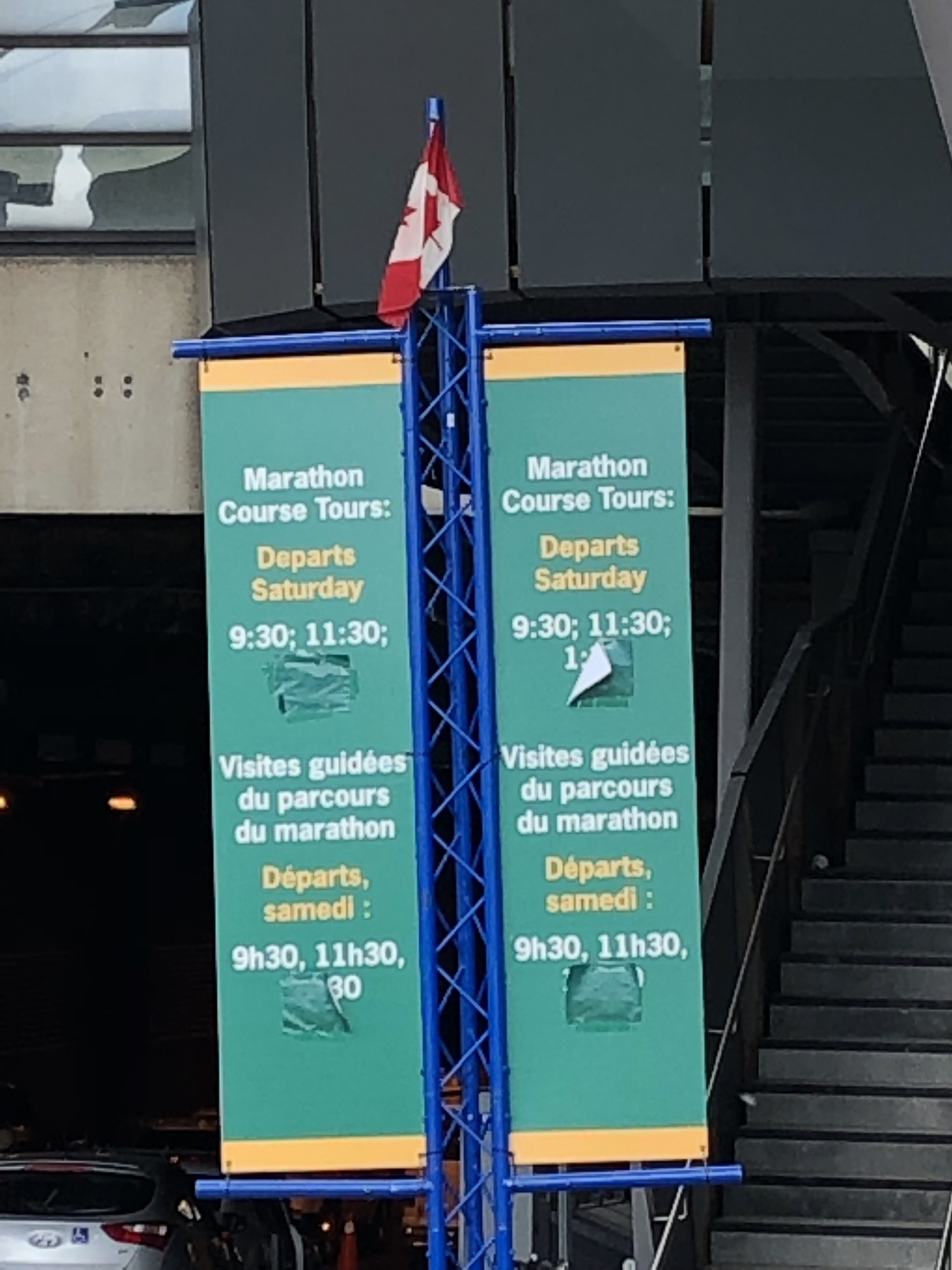
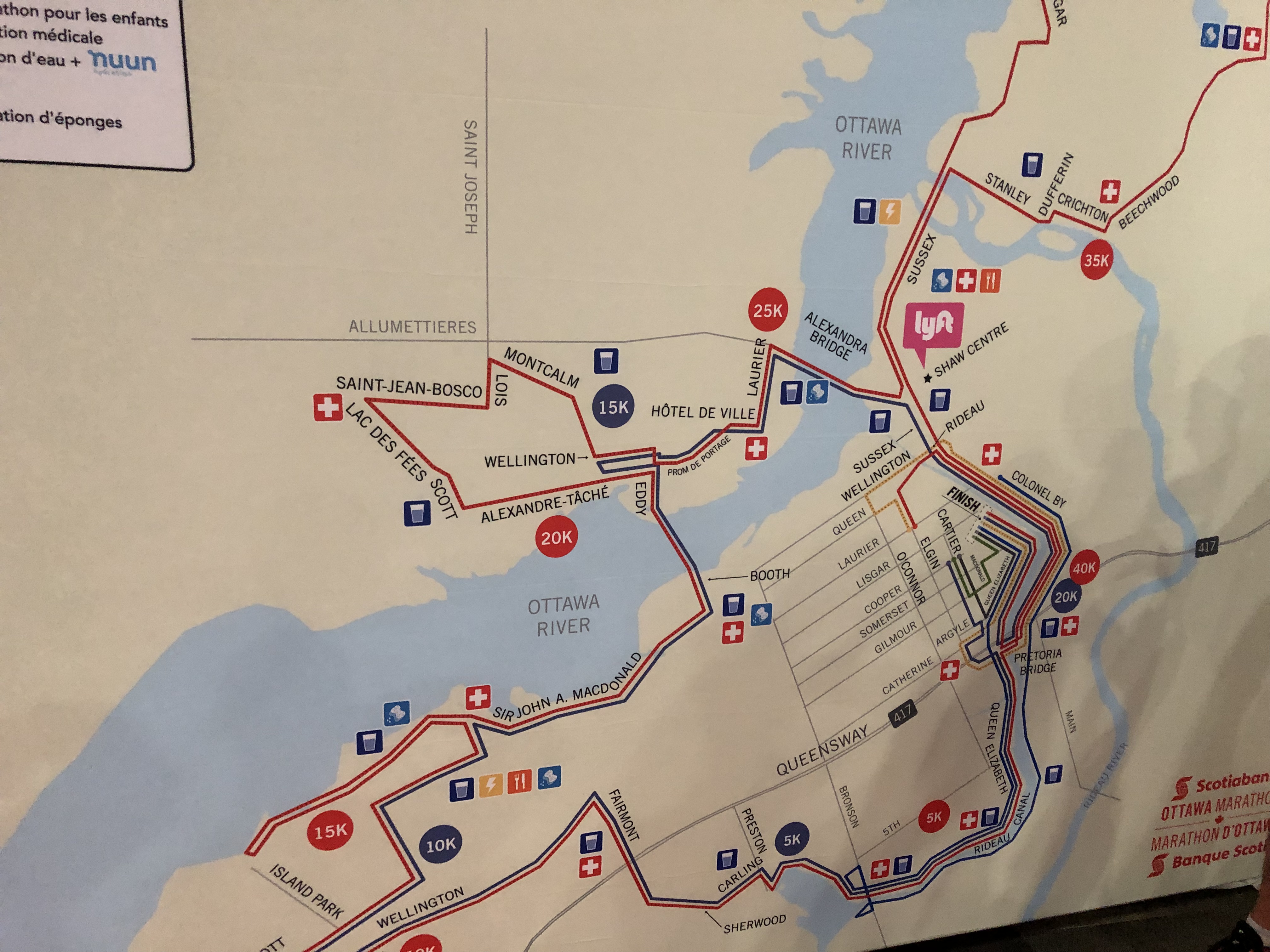
Although I had a full day of work on my first full day in Ottawa, I took a bit of time in the morning to head to the convention center and register for the race. Since it was early, there weren’t lines for anything and I came out pretty quickly. Aside from the bib pickup itself, there were a few sports brands hawking various products. One thing did catch my eye though, signs for a bus tour of the marathon course that would be given the next day. I’d seen the printed course map online, but thought it could be nice to see the course itself so I knew exactly what surprises were in store for me. That meant I was up bright and early at 9:30 a.m. the next day after having a quick breakfast to board the tour bus. I was given a course map, and followed along from there.
A sign with details on the course tour times. These only ended up attracting a few runners, tho. Course map for the Ottawa Marathon. The marathon course is red, the shorter half is in blue.
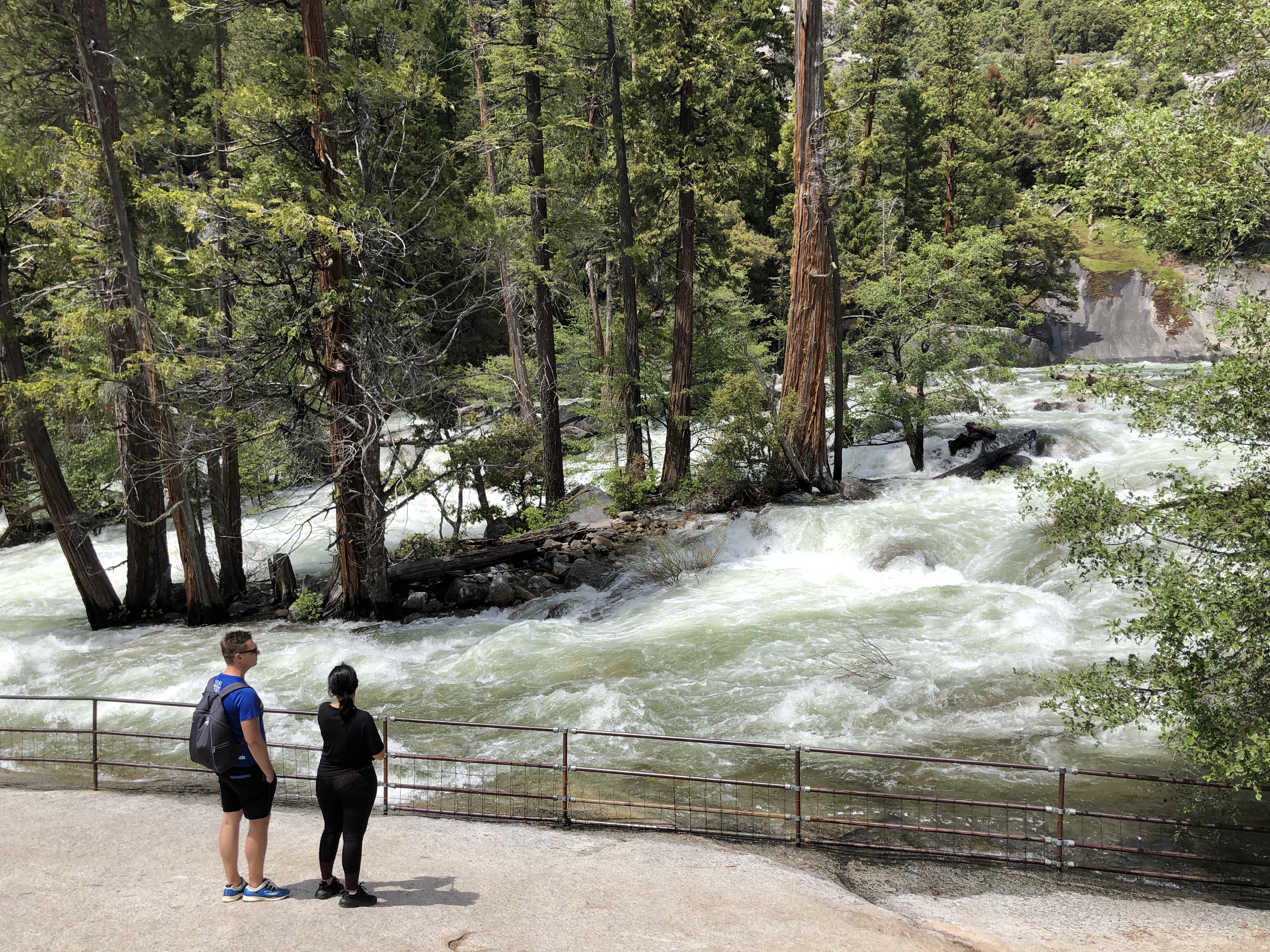
The ride started pretty smoothly, following the Rideau canal that we’d be running along. Even though the tour guide was mostly there to explain the course, she also spent a good amount of time talking about the city’s history itself. She explained the early importance of the Rideau canal, as well as the city’s beginnings being rooted in a history of logging. She even went over a period of lawlessness, when the town sheriff essentially gave free reign for anyone to shoot anyone else to resolve their disputes over a couple of weeks. Shocking for the capital of a country known now for its politeness! After leaving the canal, we bussed through suburbs for quite awhile, passing through residential and commercial districts alike. I was encouraged by all the houses we’d be passing, meaning that locals would likely come outside to cheer. We wound up the MacDonald expressway, a hilly expressway that was exposed to the wind. Our guide mentioned then how the course actually had to be rerouted over a higher bridge, as the original one had recently sunk too close to the current floodwaters of the Ottawa river. We crossed that bridge into Gatineau, the suburb in Quebec where the primary language switched to French on all the street signs. Still not much to worry about. We crossed the Alexandra bridge back into Ottawa, before heading northeast to the wealthy Rockcliffe Park area. This is where most embassies and their residences were located, with the US embassy in particular getting a shoutout. We were done after this hilliest part, but it was then that I noticed we’d been on the bus for 90 minutes! If the course took a bus that long… how long would us runners take?
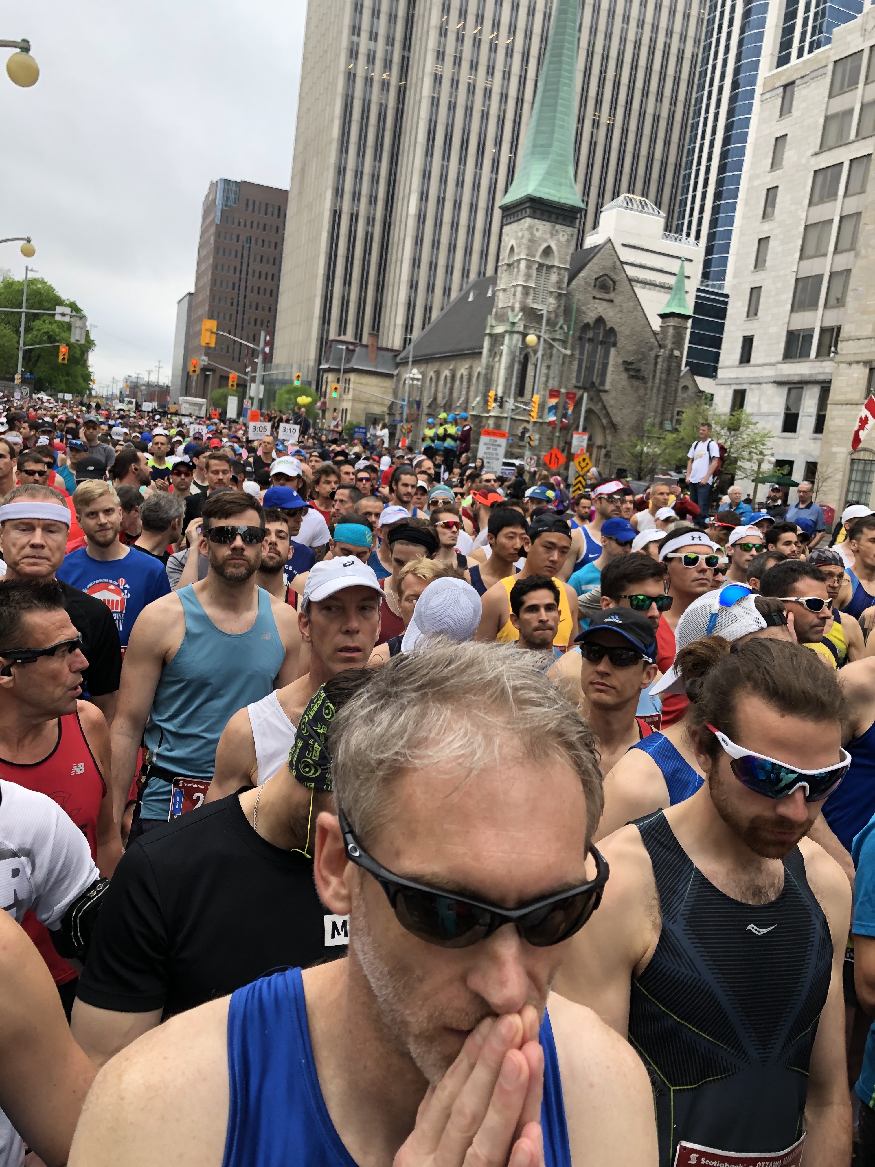
I spent the rest of the day working but otherwise relaxing at my AirBnB. I slept early for a full 8 hours thankfully, despite fears that noise from nearby bars watching the Toronto Raptors beat the Bucks for a trip to the NBA Finals would be raucous. I took my time waking up, sipping on water and chewing through a couple bananas. One of the advantages of being so close to the start line is that I could saunter out of my AirBnB just 40 minutes before the start time to do my warm ups. Despite heavy rains the previous night, it was cool and dry this morning, great weather for a long distance run. I wrapped up my warm ups just 10 minutes before the race, as runners were starting to cluster in their starting zones. Just like in Hong Kong, I rustled my way through the crowd until I was near the front of my group, within sight of the elite runners. They were pacing with their final warm ups as well, and the announcer was talking about their ambitions for the race. Male pacers would go for a 2:06 finishing time, blistering by anyone’s standards, but a stretch even for this gold label course. I’d just be trying to finish within an hour of that as a stretch goal. Part of me hoped I could just run a perfect race and qualify for Boston right here. However, it was more realistic that I’d finish 5 to 15 minutes short of that, at a pace just above 7 minutes per mile. At 3 minutes to, a singer came on for the national anthem: “O Canada”. I really shouldn’t have been surprised that it wasn’t the Star Spangled Banner but I was, and as I took in the daunting task ahead of me, I felt my adrenaline start to surge. Canada’s national anthem still gives me chills because of this moment. Soon afterwards, the morning was shattered by a gunshot at 7 a.m. sharp that sent us on our 26.2 mile task!
The elite running group warming up ahead of the race The 3,800 other runners this year gathered behind me, ready to run!
Just like in the Hong Kong race, I felt good and started out fairly fast, even coming within reach of a couple of the elite female racers. However, I tried much harder to restrain myself after the chaos of the first kilometer and settle with some faster runners passing me. I settled into a pace around 6:45 per mile, and decided to just try to hold that and see when the 3 hour pacer would eventually catch me. I hoped it would be after the halfway point, and that his group would help energize me towards a fast finish for the rest of the race. I hit the 5k mark almost 30 seconds ahead of the 3 hour pace, so I was feeling pretty good about that lead. As we left the Rideau canal and headed into the suburbs, the crowds increased and most residents were watching from the sidewalk or front yards. Quite a few had even brought their leashed dogs to watch with them. Acknowledging the fast pace we were trying to maintain, they cheered “Way to go future Boston qualifiers!” and other references to that legendary race that we were on pace for. It was a much appreciated ego boost for sure!
I was still cruising as we approached the 10K mark in Wellington Park, when I had quite the surprise. I felt someone taller looming on my left side, and they paced just behind me for a minute before gradually cruising a bit in front. I was shocked to see the bunny ears and sign above his head, and with dread I realized what the sign read: 3:00. This was the pacer I’d need to keep track of in order to qualify for Boston, and he’d caught me just a quarter of the way through the race! We crossed the 10k mark about 20 seconds ahead of 3:00 pace, but I was a bit miffed nonetheless. I still felt good, so I clung to the end of this pacer’s group and stuck with them. We continued churning through miles in the suburb before climbing on the windy, hilly MacDonald expressway. Despite the worse conditions, I was still able to stick to the pacer. I hadn’t budged at the 15k mark, and as we crossed the bridge near 20k into Gatineau I was starting to wonder if I could really do it!
Here however, the pacer started to draw a little further from me, and I realized that I couldn’t charge forward and stick with him for much longer. I crossed the halfway mark still ahead of the 3 hour pace at 1 hour, 29 minutes and 30 seconds into the race, but I wouldn’t be sticking to the Boston pace any longer. I slowed up to just over 7 minutes per mile and started thinking about saving energy. It would still be quite some time before the 3:05 pacer caught me, and if I was disciplined I might even be able to prevent that from happening. Running through Gatineau itself was also invigorating, as the cheering and signs swapped from Engilsh over to French, and locals watched us from outdoor brunch cafes. Despite Gatineau’s rolling hills, I didn’t slow up much and even passed a couple runners on the bridge back to the Ontario side. Only the last third was left, and I was feeling ready for it!
However, that feeling started to fade after I actually made the turn toward the Rockcliffe loop. For reasons I still don’t quite understand, I went at Mile 18 from feeling like I could stay ahead of the 3:05 pacer to starting to wonder if I’d be able to finish the race. As if on cue, the 3:05 pacer passed me during Mile 20 as we ambled past the US embassy. After the ups and downs here, I slowed up further and started accounting for all the parts of my body that were in pain. My longest run to this point had only been 19 miles, so I was truly in uncharted territory and much less prepared than I’d hoped. I’d joked with friends before the race, saying that since I’d run those 19 miles the morning after 3 beers and a couple cocktails that the handicap showed I’d be prepared for a fully sober 26.2 mile race. However, this was starting to be a shaky theory as I headed, ever slower and unsteadier, on the final stretch back towards the Rideau. The 3:10 pacer passed me at this point, and I was no longer sure I could even stay ahead of the 3:15 one.
All of a sudden, as I passed Mile 23, a kid no more than 5 years old burst onto the course with an Otter pop in his hand. The top was cut off, and he came running right up to me to hand it off. Yes, I was going so slowly at this point that a 5 year old was capable of pacing with me for a bit. I tentatively took the otter pop, but I nodded and smiled as best I could to show my appreciation, and that he’d picked the right person. I slurped the thing down in seconds, and felt a sudden sugary jolt that lent me a bit more energy. My sore muscles became just a bit lighter, and although they didn’t feel like surging any faster, at least they didn’t feel like they were in danger of cramping for the time being. That could actually end my race, a painful couple of miles from the finish line itself. I tossed aside any more thoughts about my time, simply resolving to put one foot in front of the other until the finish line, now just 5 short kilometers away.
Those last 3 miles would end up being the slowest, and toughest, of my entire life. Pain started shooting up through my legs with every step, even my well padded shoes couldn’t prevent that anymore. And as I crossed the 40k mark, the cramps I had felt threatening me just before I received the otter pop started to make themselves known again. I started to run while massaging the back of my sore thighs, just hoping I could keep them going for the remaining stretch. I wanted above all else to not ever stop my running until crossing the line, if at all possible. Somehow, step after step, I continued to hold a steady 10 minute pace and amble onwards to the line. Past an increasing number of runners that had fallen by the side of the road, clutching various cramped muscles. One of which was the 3:20 pacer, who I hadn’t even seen pass me. The pain in my muscles intensified just as the finish line came into view, though. I had to stifle my impulse to just go for the line, and still focus on keeping my muscles from cramping up. I clenched my teeth and plodded forward, step after agonizing step, inching closer to the line and willing myself to not fall over until I’d crossed it. Finally, after 3 hours, 25 minutes and 23 increasingly brutal seconds, I crossed over and stumbled forward just 3 steps later.
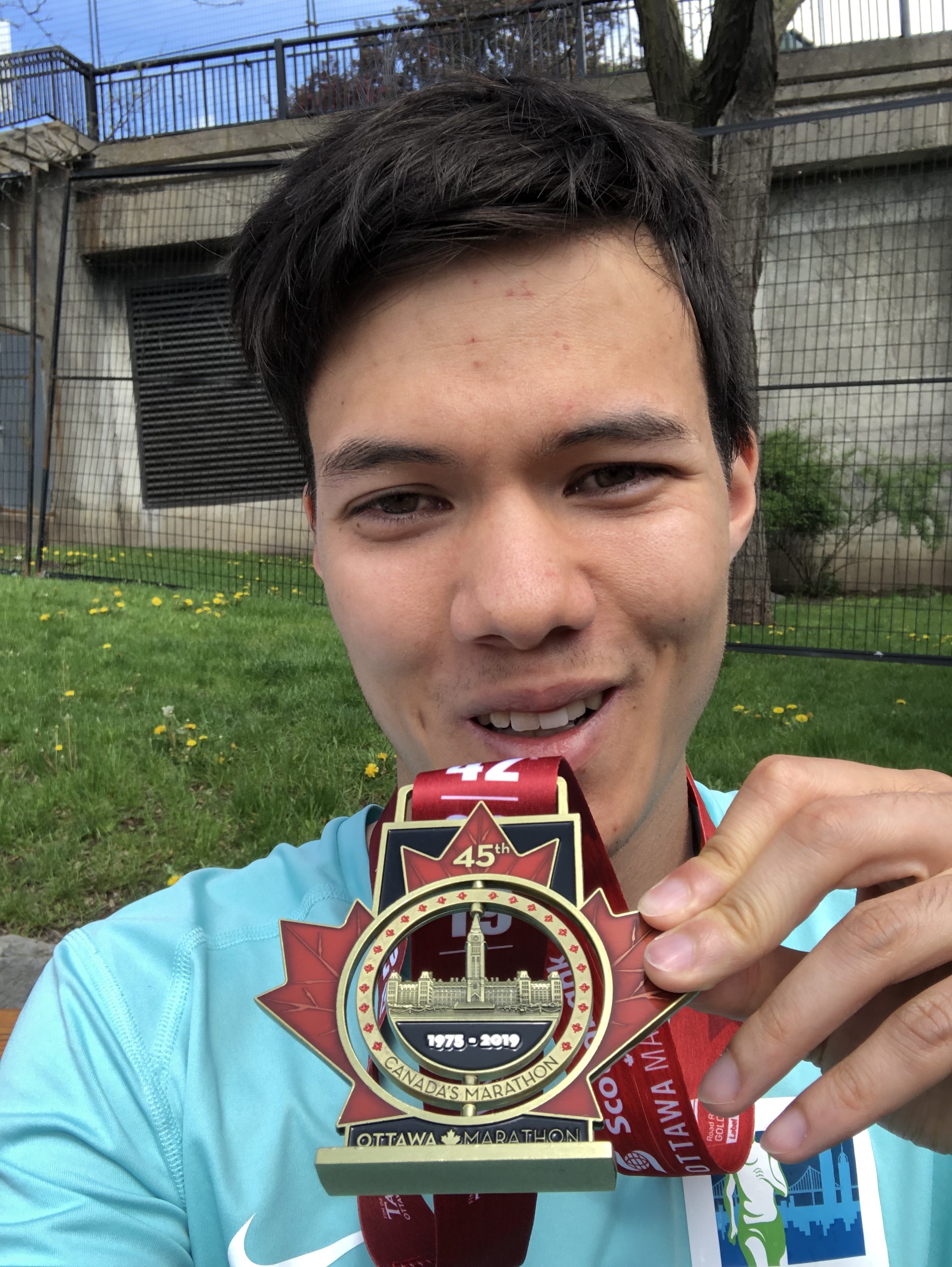
A staff member caught me on his shoulder and guided me to a railing by the side, out of the raceway. He propped me against the fence as I caught my breath and felt my adrenaline ebb, bit by bit. It took nearly 15 minutes, but the feeling eventually returned to my legs, and I was able to head through the post-race lineup on my own legs. There, I received the finisher’s medal for the race. It was a lovely maple leap emblazoned in dark red, with the parliament hall attached in the center, a section which would spin around on its own. It was the most beautiful medal I’d seen by a long shot, and I was so, so thankful to see it now. I collected it along with a bottle of water and a bag of light food, and collapsed onto the first bench I found. I watched runners, some now joined by their adoring family members, stream past me as I slowly recovered. It took nearly an hour before I could summon the will to rise from that bench. Even though my bib guaranteed me a finishing beer, anyone who’s ever finished a marathon knows that’s the last thing you want after 26.2 miles. You’d probably just throw it up!
All smiles once I got the medal! But my legs were still in extreme agony
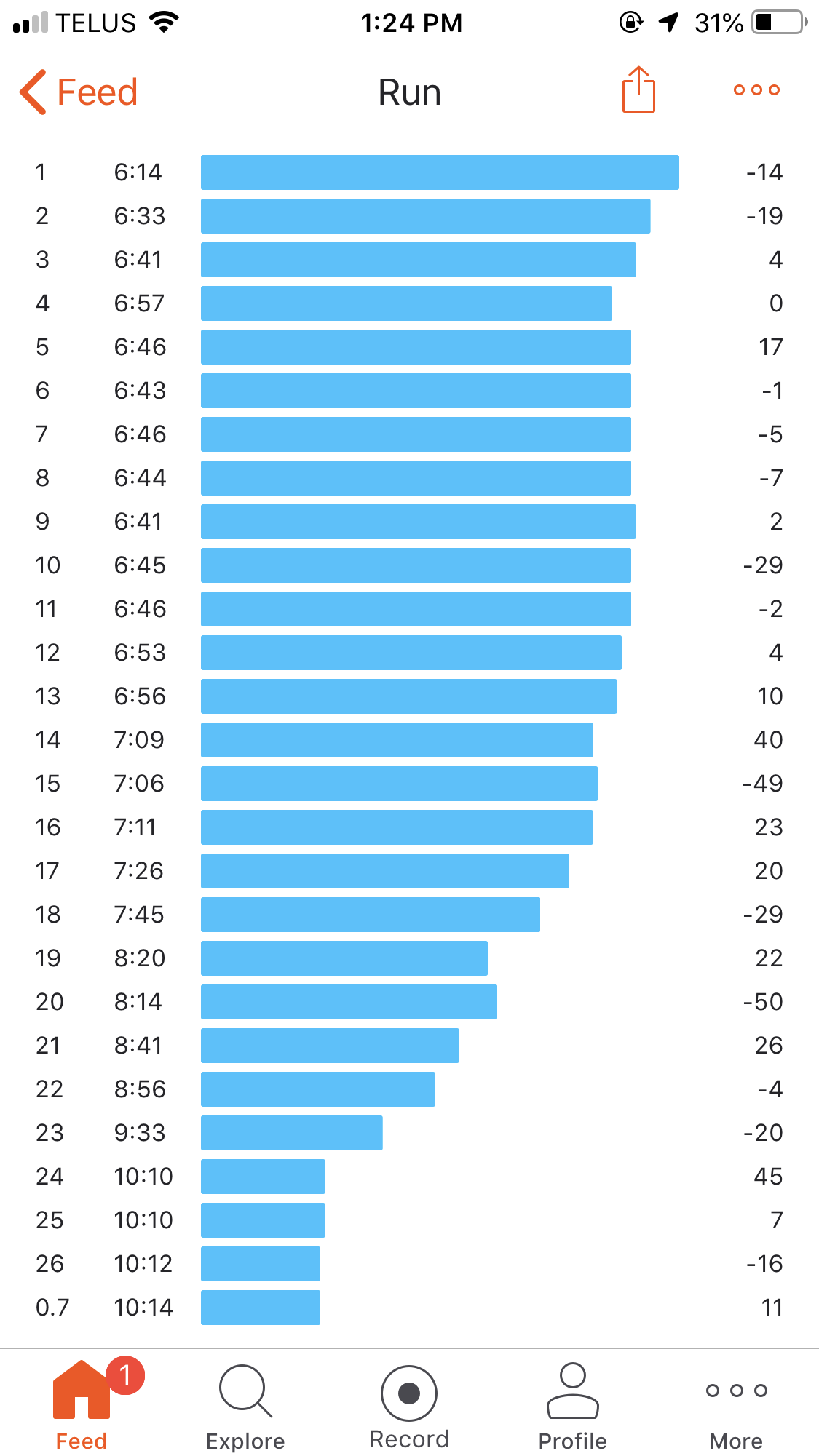
Despite the happy ending, my Strava graph showed that I had a LOT to learn. Once again, my first mile was a blistering 6:14 which had grouped me with a couple elite runners at first. The first mile of a race can be crazy with lots of jostling, and going out fast helps me avoid all of that. However, the cost is having to recognize that and slow down significantly after we’re out of the woods, and I still have trouble doing that. Although I was able to clutch below the Boston pace for the first half of the race, it definitely wasn’t worth the marked decline I got throughout the second half of the race. Furthermore, my performance suffered dramatically once I got past the point of my longest training run, after 19 miles. I would have to train at the actual race distance, possibly beyond it, if I hoped for my practice to actually predict for my performance on race day. This race was a promising start towards one day qualifying for Boston, but it was not a predictor that I’d do it by any means. Once again, I was reminded that the ultimate goal is always, always to finish the race. I felt it much more urgently than I had in Hong Kong, as I finished this one with probably less than 10 steps left in me. That’s an extremely narrow margin of error for a 26.2 mile course! Even though I was 25 minutes behind my dream time, and 10-15 behind a reasonable goal time, I couldn’t have been prouder of finishing the race after holding such a fast pace for the first half. Although COVID has put the breaks on racing for the time being, I look forward to ramping up for my next marathon in the years to come. More than anything, I’m glad I got at least this one behind me before that tragedy changed all of our lives for the time being. It reaffirms my belief that you should take these opportunities as they come, especially as it comes to light now more than ever that they are not guaranteed by any means.
My split times from the Ottawa Marathon, which honestly tell most of the story…
In November of 2018, I’d finally decided to sign up for my first marathon, and try to take a lofty shot at qualifying for the Boston Marathon. I signed up for the Sydney Marathon that September to pursue my goal, but I wanted a “warm-up” race first. Something far enough removed from the Hong Kong half marathon in February, but not too close to September, and preferably one over the 3-day Memorial Day weekend to maximize time in the race city. After some searching, I found that the Ottawa Marathon fit the bill almost perfectly. It wasn’t too many timezones to adjust from home but it was in a city I’d never been to before, and was a mostly flat course that was certified as one of just six IAAF Gold Label marathon courses in North America! Unlike Washington D.C. of the United States, Ottawa doesn’t have that many flights outside of Canada. Because of lower supply, fares can be really high. Roundtrips without overnight layovers were pricing out at nearly $1000, which is a crazy amount to be spending on a cross country flight. I was able to find a one-way flight back from Ottawa on United for around $170, with a long layover in Washington’s Dulles airport during my working hours the day after Memorial day. However, this left me needing a one-way to Ottawa, and literally nothing was pricing under $500 the Friday before the race. Mercifully, Westjet decided to host a sale and filed a one-way from SFO to Ottawa with a layover in Calgary for just $200, the Thursday before the race. Even though it would put me in Ottawa just past midnight, I wasn’t willing to spend hundreds of dollars for an option with better timing.
However, I lucked out with schedule changes on both of these itineraries. First, United moved my flight from Dulles to SFO back by an hour, which empowers me to pick any alternate flight that same day with open seats. I decided it would be a good idea to spend the afternoon back in our office, and changed to United’s first flight to Newark with a connection to SFO that would get me back at 11:30 a.m. Then, my Westjet flight from SFO to Calgary was pushed 3 hours earlier. My other option was a 4 hour layover in Vancouver with a similar morning departure, but I’d arrive in Ottawa at 9 p.m. instead of midnight. I happily made the change, as Westjet provided inflight Wifi for purchase that allowed me to work on the way to Ottawa. I had no lounge access in Vancouver, but most gate areas were pretty empty and I had 3 hours of intense focus after clearing Canadian customs and transferring to the domestic terminal. In the end, my flight itinerary looked like this, all in Economy class:
Outbound:
Westjet 737-700 Flight from SFO to Vancouver
Scheduled Departure: 8:00 a.m., Thursday May 23th, 2019
Scheduled Arrival: 10:00 a.m., Thursday May 23th, 2019
Scheduled Duration: 2 hours
Layover Duration in Vancouver: 4 hours
Westjet 737-700 Flight from Vancouver to Ottawa
Scheduled Departure: 2:00 p.m., Thursday May 23th, 2019
Scheduled Arrival: 9:30 p.m., Thursday May 23th, 2019
Scheduled Duration: 4 hours, 30 minutes
Return:
United CRJ-700 Flight from Ottawa to Newark
Scheduled Departure: 6:05 a.m., Tuesday May 28th, 2019
Scheduled Arrival: 7:40 a.m., Tuesday May 28th, 2019
Scheduled Duration: 1 hour, 35 minutes
Layover in Newark: 35 mintes
United 777-200 “Megabus” Flight from Newark to San Francisco
Scheduled Departure: 8:15 a.m., Tuesday May 28th, 2019
Scheduled Arrival: 11:30 a.m., Tuesday May 28th, 2019
Scheduled Duration: 6 hours, 15 minutes
The next important consideration was where to stay while in Ottawa. Although the metro area is pretty spread out now with nearly a million people, most of the places I thought I’d be interested in going were clustered near the Parliament buildings at the city center, all within a mile and a half of each other. My first concern was picking a place that would be close to the starting line, which was on Elgin street right in front of Confederation Park. I found an AirBnB for about $350 total over the 5 nights I had to stay in the Golden Triangle district, which is along the city’s famous Rideau canal and just a few blocks from the race’s start. A secondary consideration was proximity to cafes and restaurants, as I ended up having quite a bit of work I had to attend to while in Ottawa. Luckily for me, I was within a block of Elgin street, which was lined with cafes and bars. I didn’t end up having time to explore Ottawa itself much until after the race, but when I did I was within a mile walk of all the important government buildings and museums. At the time, 5 nights was a lot for me to spend in any one city, especially one as small as Ottawa. The time felt shorter because I spent half the time working, though, and I ended up being really impressed by the cafes and restaurants I tried. This trip also nudged me further towards taking longer trips to work remotely in certain cities, which I appreciate.
From Glacier Point you can see each of Half Dome, Vernal and Nevada Falls, Liberty Cap, and even Cloud’s Rest!
On my group’s second day, we decided to drive up to Glacier Point. It’s reached by a road that branches off of highway CA-41, which enters Yosemite Valley from the south. We drove in from an AirBnB at Wawona so we didn’t have to pass through the valley, but drivers coming in from CA-120, CA-140, or the valley itself will have to take a branch off that takes you out of the valley through the long, straight Wawona tunnel. Just before the tunnel, there’s a parking lot at Tunnel View, which also has an overlook of the valley. I went there with another group for sunrise a couple of weeks prior. It turned out to not be a great spot to watch, however, because the sky gets lighter much earlier than the sun itself rises above the valley walls. So while it was pleasant to watch the valley and its landmarks appear in shades of muted blues and grays, you may not see as many of the orange and red hues that usually accompany a sunrise. We took advantage of our early start, and stopped by a couple other Yosemite Valley landmarks before driving back to our AirBnB for some rest. The empty roads and parking lots were a stark contrast to the traffic jam we’d had to wade through the previous day, and we were grateful to not have to do it again.
Yosemite Valley in more muted colors around sunriseWawona Tunnel, with bright yellow lights to help drivers navigate the tunnel safelyBridal Veil Falls, which also generates a shroud of mist, but a smaller one than you’d see at Vernal FallsThe creek that runs from Bridal Veil fallsThe sheer size of the valley’s stone walls is always a stunning sight to beholdLower Yosemite Falls in the morning light. Upper Falls is obscured by a tree
Back to Glacier Point, it takes about an hour one-way to get there from the valley floor. There’s a sizable parking lot at the end of the road, though I imagine it can fill up and there’s no nearby alternate option for parking if it does. We secured a spot shortly after 9 a.m., and cars were circling and waiting for spots by the time 10 a.m. rolled around. So, 9 a.m. is the benchmark you should shoot for on a weekend if you want a spot at Glacier Point, based on my data point.
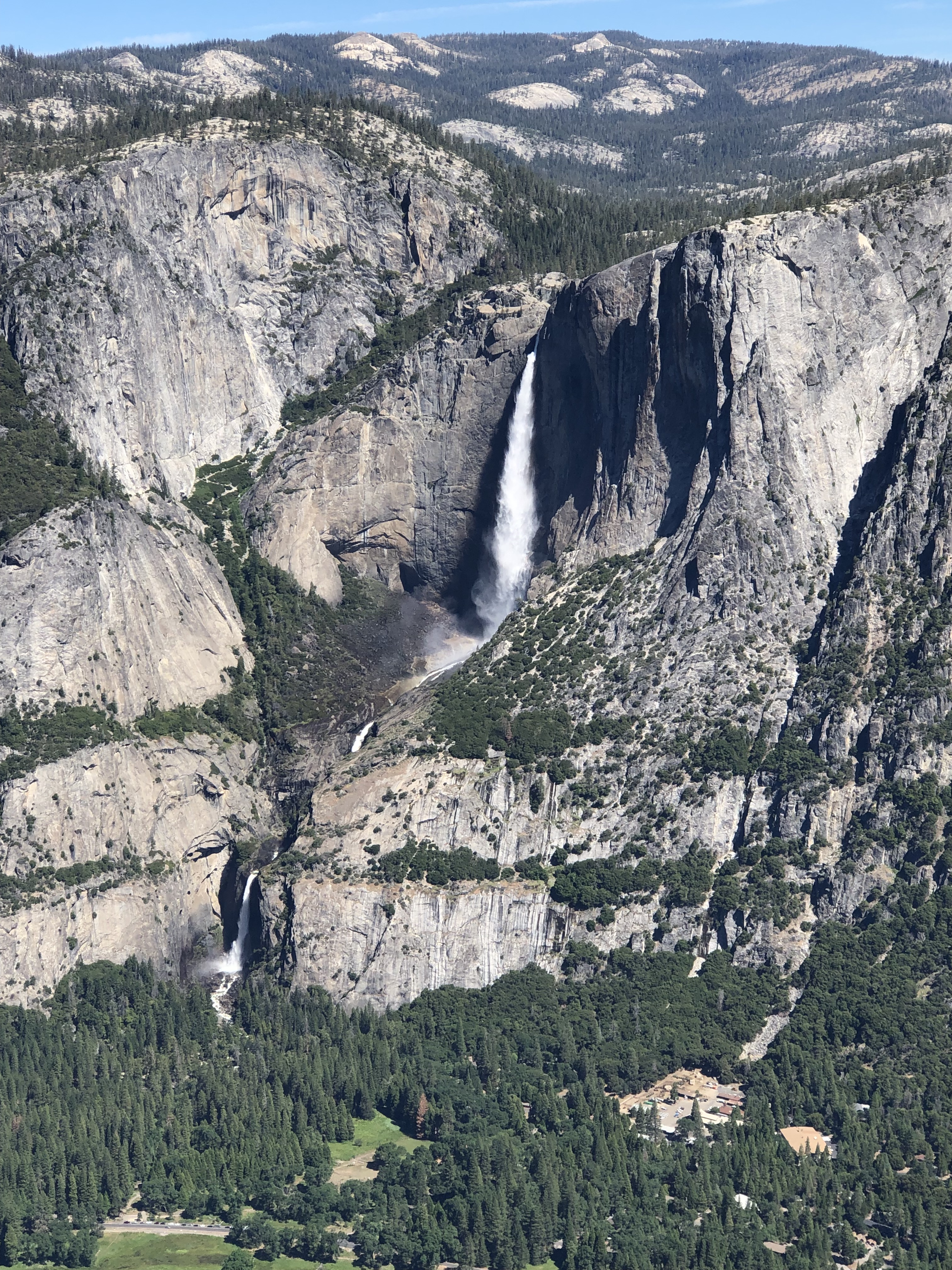
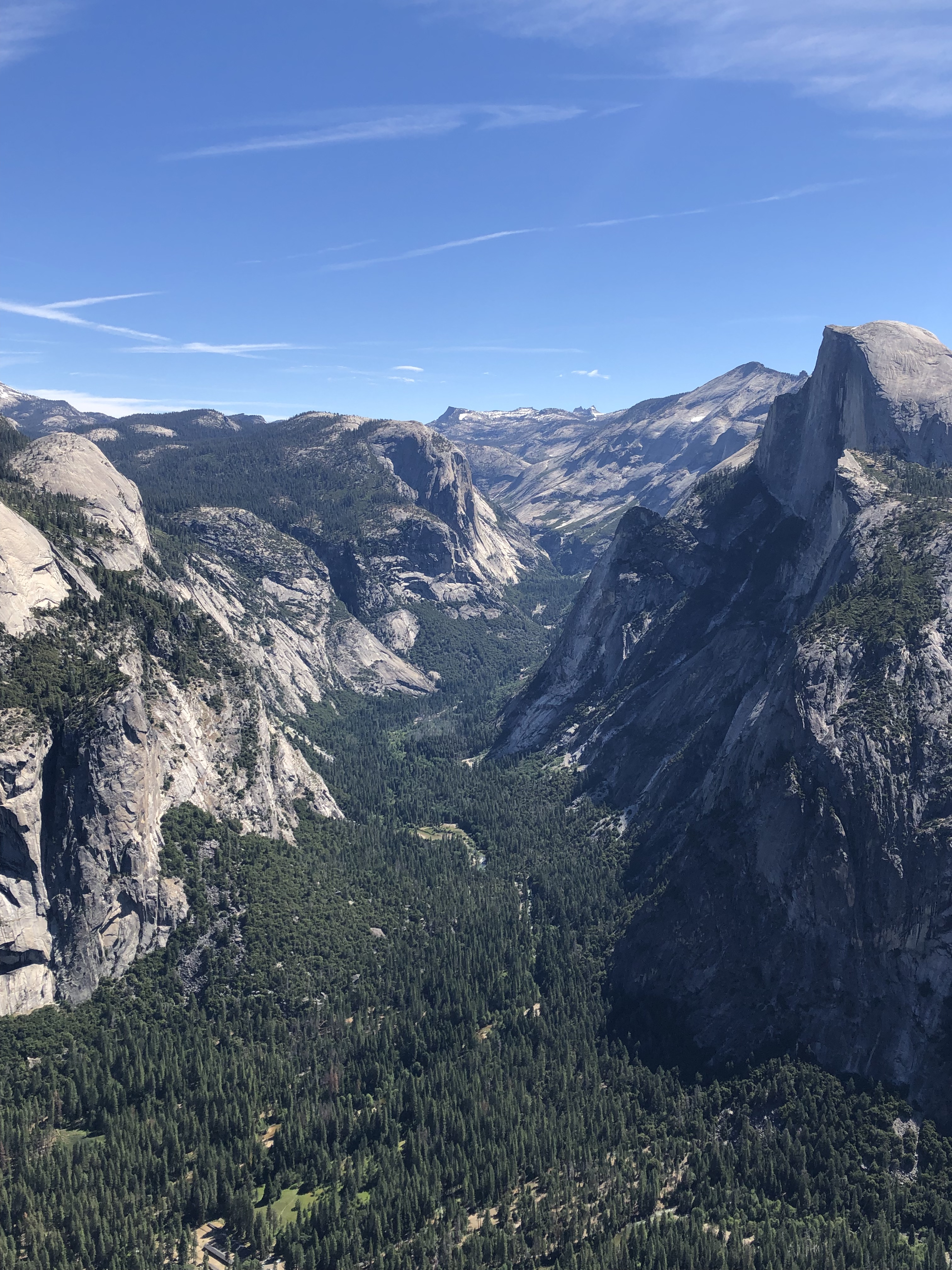
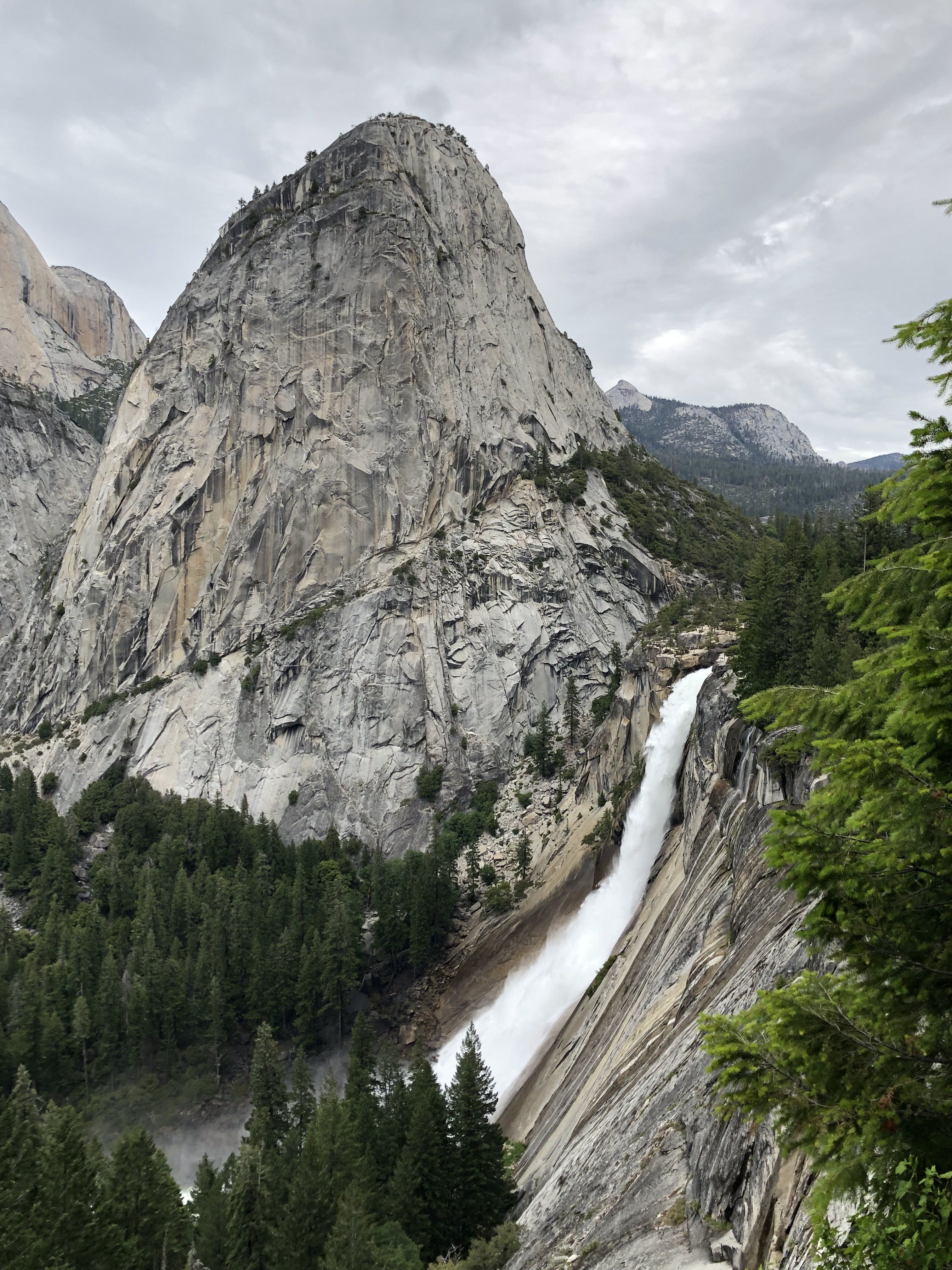
There are a few trails that stem from Glacier Point, including one dropping over 3,000 feet to the valley floor. However, we planned to hike on a less trafficked trail and just went to the viewpoint. What you’ll see one-by-one as you drive through the valley, you’ll see all that and more from Glacier Point itself! The valley floor stretches out below you, beyond a sheer, staggering drop. El Capitan is less recognizable from here, so your first landmark to the left will be Yosemite Falls. From this vantage point, both the upper and lower falls are clearly visible in all their splendor. You can look straight below to the valley itself, where you’ll see its lush, green meadows. Further east, you’ll see the meadows replaced by trees as the valley floor rises steadily. Overlooking this part of the valley is Half Dome, which is the most recognizable Yosemite landmark from the air. Far beyond Half Dome is Cloud’s Rest, which is much harder to make out. In the far right of the viewpoint, Vernal and Nevada Falls come into view, which are the two waterfalls that we’d hiked up the previous day. Being able to see the entirety of the trails we’d taken yesterday all at once, suddenly gave us a scale of how little of Yosemite we’d actually hiked through. It also became more clear how crazy steep some of the sections of trails were that led up the side of the falls. Because you can see everything at once, I’d actually recommend this as the starting point of a Yosemite trip, especially for anyone coming south of the valley. If you’re willing to be a super early bird, I think a sunrise here would be spectacular. Once you’d gotten a chance to take in the sheer scale and beauty of the valley, you could meander down there by car and still arrive before there’s fierce competition for parking spaces. Also note that the Glacier Point road closes down during the snowy season, which can start as early as October and last as late as May.
Glacier Point is one of the best spots for viewing the entirety of Yosemite FallsThe valley floor stretching onwards and upwards, to the east, still flanked by Half Dome to the rightCloseup of Half Dome itself, a cathedral-like edifice that overlooks Yosemite ValleyVernal and Nevada Falls, which feed the Merced River that gives the vibrancy of life to the valley floor
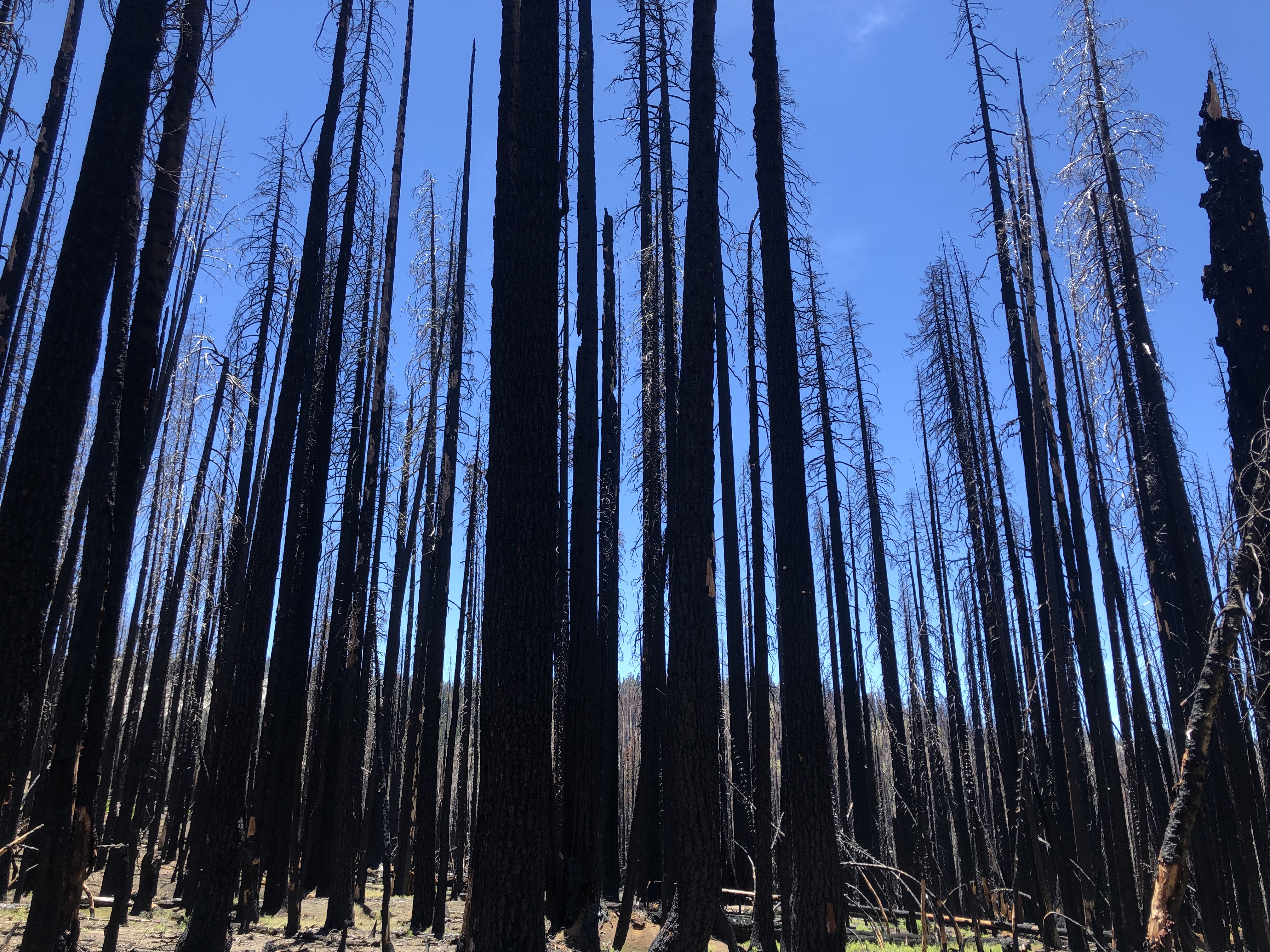
Afterwards, we chose to do the hike to Ostrander Lake. It’s a 12 mile roundtrip, but doesn’t come with steep sections or intense elevation gain. However, there’s also less to see along the way. We had some alpine meadows and grassy forests, but that’s about the extent of it. A little more than halfway along, we also got to the burned out husk of a former forest. Seeing that we still had a long way to the lake, we decided to call it a day and turn around. Based on what we saw, I definitely wouldn’t put this hike at the top of any Yosemite list. Maybe that changes if you go all the way to the lake though, especially since you’d have it mostly to yourselves. The trail is off the beaten path, which is mostly why we picked it, so it could still be a side option if the parking lot at Glacier Point fills up, or you want to avoid crowds.
The burned out forest that we encountered halfway through the Ostrander Lake trail, along the Glacier Point road
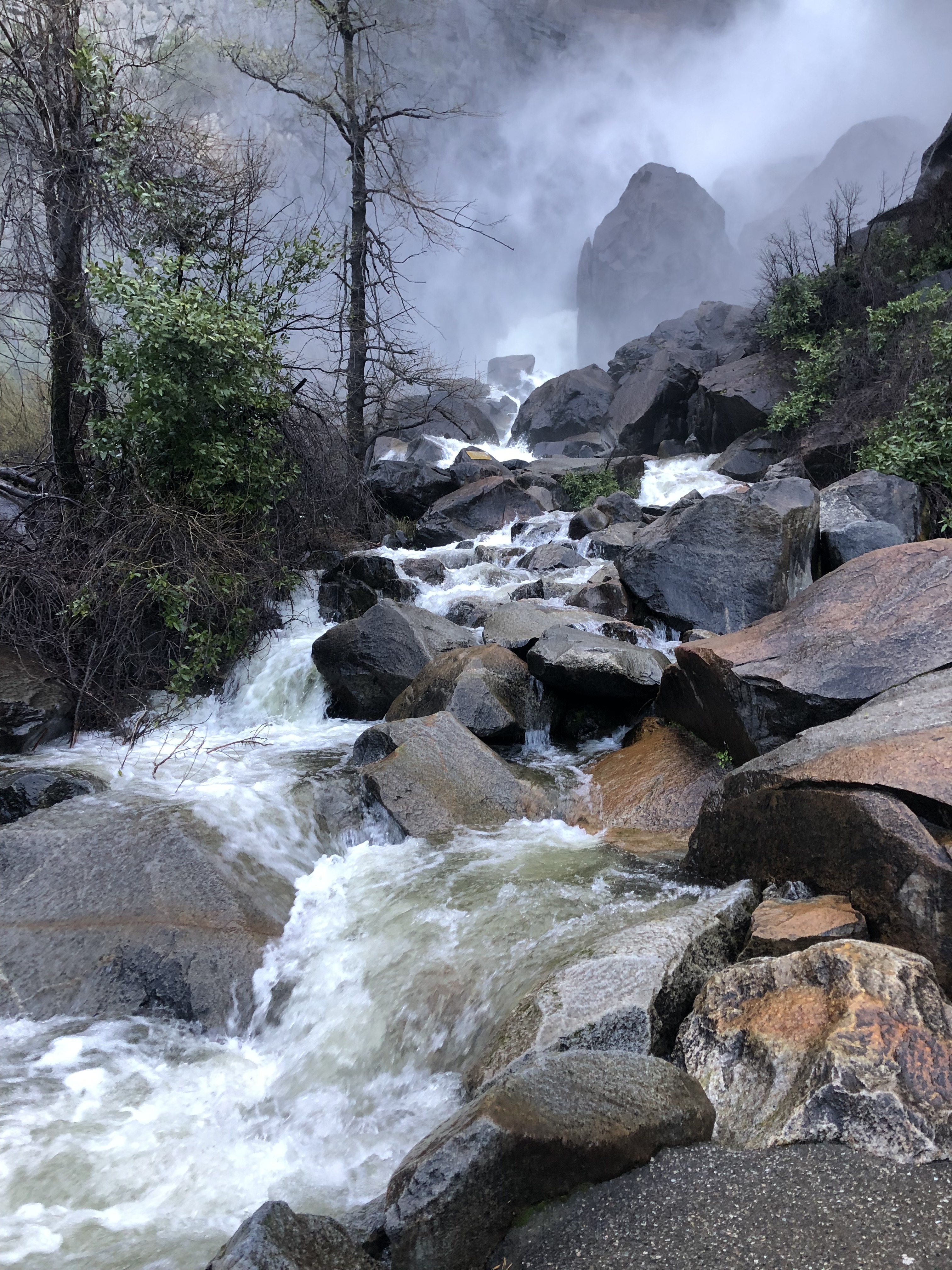
The top of Vernal Falls, seen from beyond the “misty” section of the Mist Trail
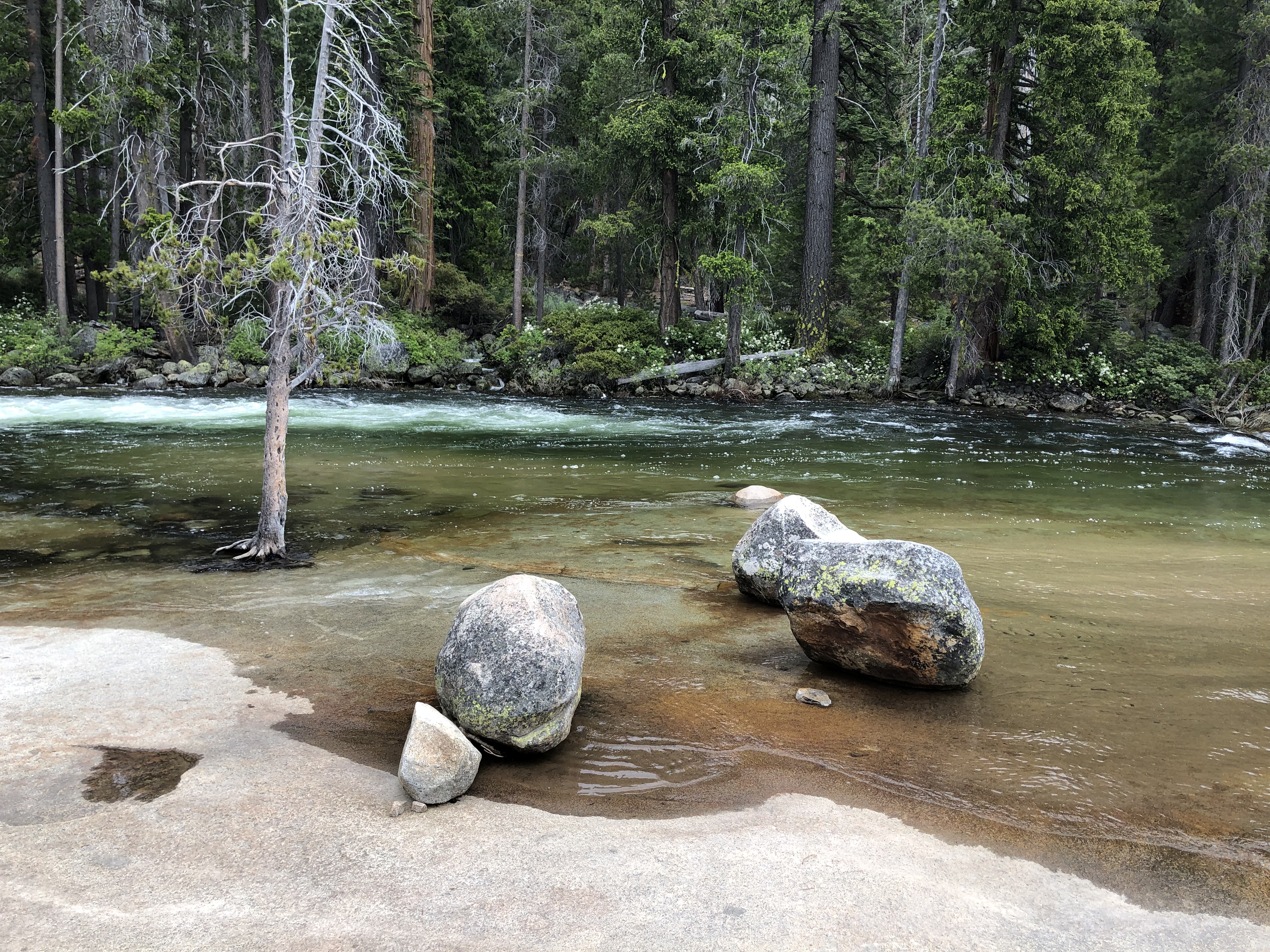
Yosemite is a large park, with many different habitats and scenic areas. However, the most famous and accessible part is definitely Yosemite Valley, and within the valley, you’d be hard pressed to find a more appealing hike than the Mist Trail. During a trip with friends last year, I proposed it for our first hike, and my party agreed to try it. In this post, I’ll recount what’s special about the Mist Trail as well as the scenic parts of the valley that you’ll pass on the way to the Mist trailhead.
In the spring months, Yosemite Falls has quite the roar of water
I actually hiked this trail two weeks beforehand with a group of interns from my company, and rode into the valley in a jeep with the top down. I’m showing posters from that trip, because I was a passenger that time, while I was in charge of driving when I went with my friend group. That time, traffic was absolutely horrendous. We got to the valley only a bit before noon, and were crawling behind traffic on the valley’s loop road. Much worse though, is that all the parking was gone. Our jeep was lucky enough to snag a space after about a half hour, but I used this knowledge to make it urgent that we get to the Mist trailhead before 9 a.m., which was early enough for us to secure parking without worry.
El Capitan, towering above Yosemite Valley’s seemingly endless traffic
The first landmark that will come into view is the massive edifice of El Capitan. It’s clear from a distance that the cliff face is massive, so you might not be surprised to learn that it’s the highest single cliff drop in the United States. It gained additional notoriety with the advent of the documentary Free Solo. Since the cliff is situated right in front of the valley road, an open-top car is the best way to photograph it this way. Continuing further, you’ll pass by Bridalveil Falls on the right side, which typically has lower flow than some of the valley’s other falls. If you arrive early enough, it’s a short side road and even shorter hike to the base of the falls which is worth doing. The other standout, perhaps the most well known one, is Yosemite Falls of course. Throughout the spring months, the falls are fueled by melting snow and plunge into the valley from a drop that’s the second tallest in the world. Your first opportunity to see the falls will be from across a meadow, like the pictures I took. However, there’s a stop later on where you can walk up to the base of the lower falls, which you may prefer to do. The meadow view is the one where you’ll be able to see the entire waterfall though, so it’s the one I’d recommend the most.
The crown of Bridalveil Falls descending into Yosemite ValleyA closer look at Upper Yosemite Falls, from across a meadow of the Merced River
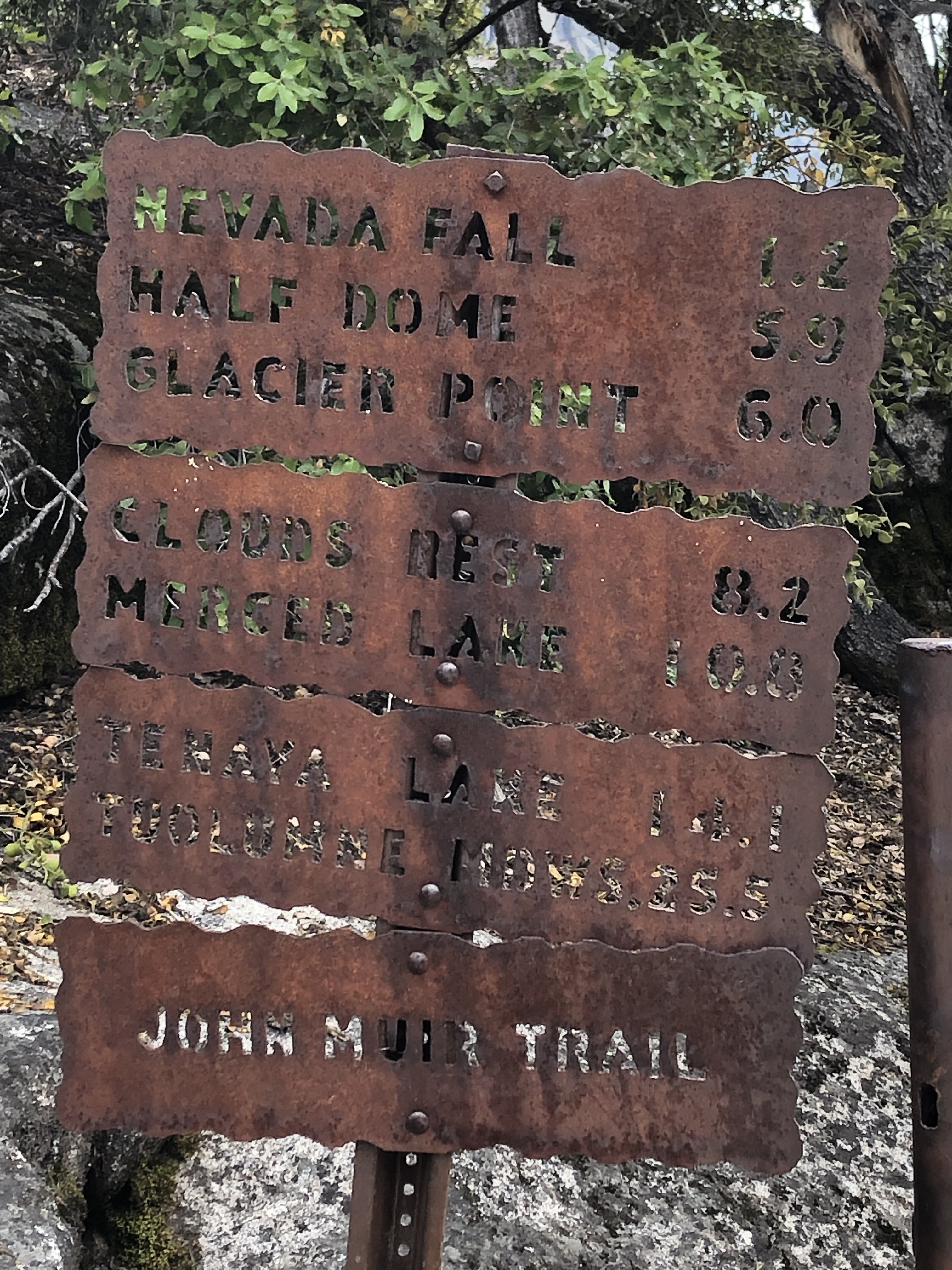
Now, let’s move on to details of the hike itself. If you arrive early enough, you should be able to park at either the Upper or Lower Pines campgrounds, or the large parking lot at Curry Village. However, if you have to just take whatever space happened to be available, you’ll need to walk to the nearest valley shuttle stop. From there, take the shuttle to Stop 16, which is Happy Isles. Do be aware that the line can be up to an hour to catch the shuttle going either to or from where you parked, so walking even a couple miles from your parking space might be your best option as well. Anyhow, the real fun begins when you get to the trailhead. If you read the sign carefully, you’ll see that it also acts as the trailhead of the John Muir trail, which extends all the way south to Mt. Whitney in Sequoia Nat’l Park! It’s also the trailhead for Half Dome and Glacier Point, and you’d have to be an extremely ambitious hiker to go any further on a day trip.
A corrugated iron sign along the Mist Trail, marking it as the John Muir trail as well
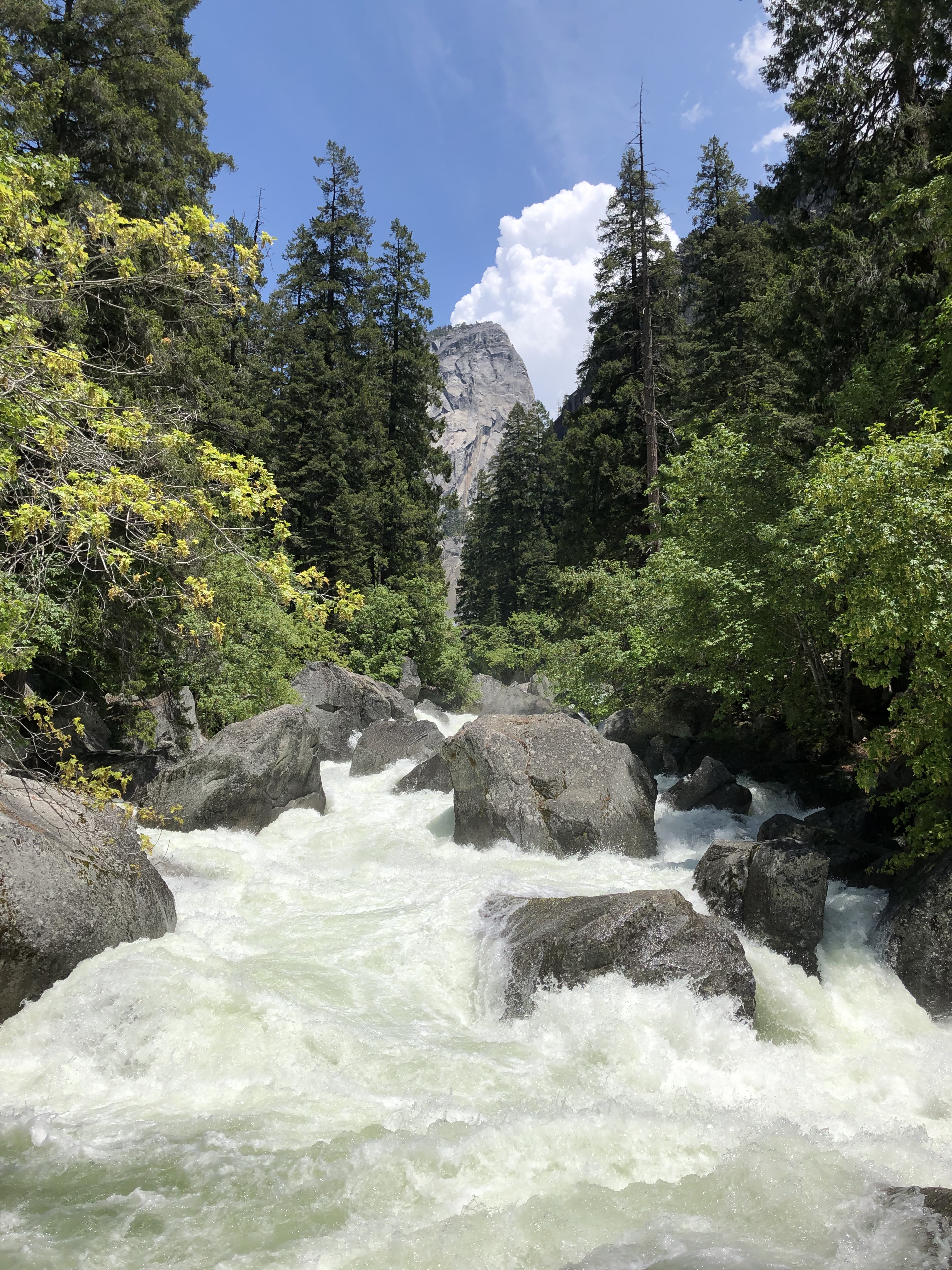
The mist trail itself starts off as a pretty steep paved trail. Right at the beginning, you can also venture around the Happy Isles in the middle of the Merced River if you want. Otherwise, you’ll continue until you cross the Vernal Falls bridge. You can see the river roar over boulders here, as the grade is pretty steep. With a good eye, you can even spot a sliver of the falls upriver. You should also be able to see a cloud of mist spiraling off the falls, which looks pretty small from a distance. However, you’ll feel differently once you see it up close!
The Merced River crashing over boulders, seen from the Vernal Falls bridgeA sliver of Vernal Falls is visible, along with the cloud of mist spewing from it
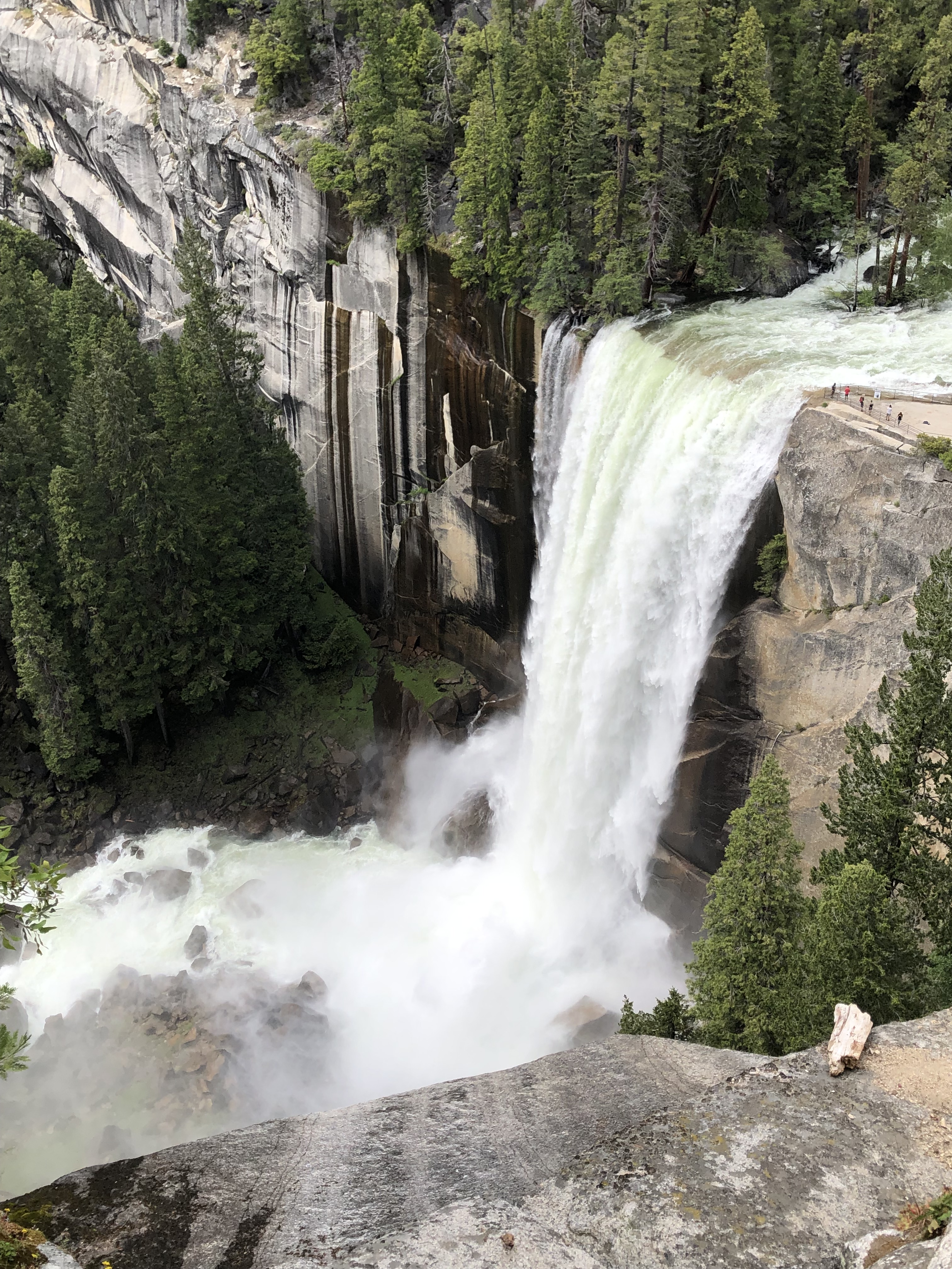
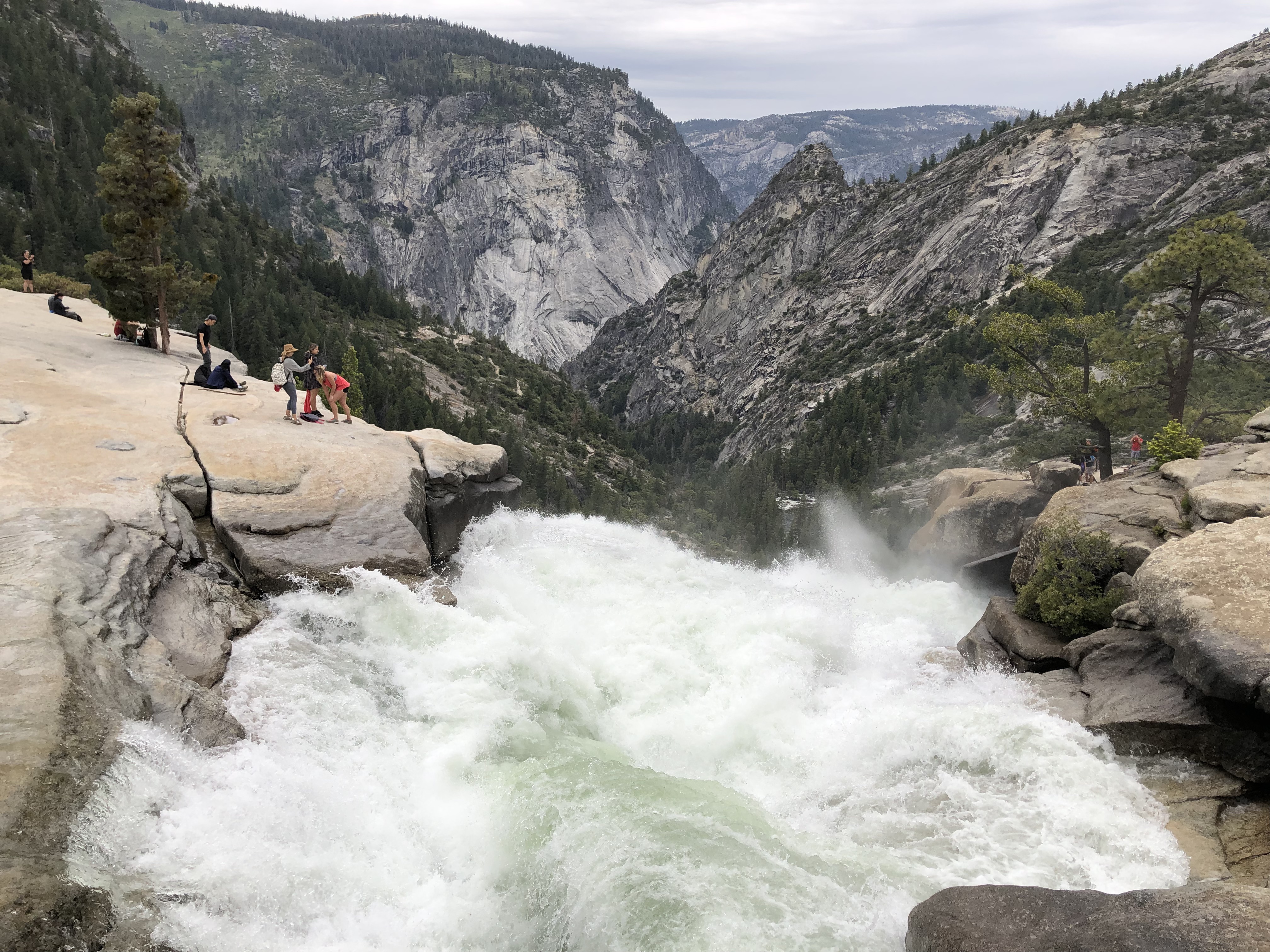
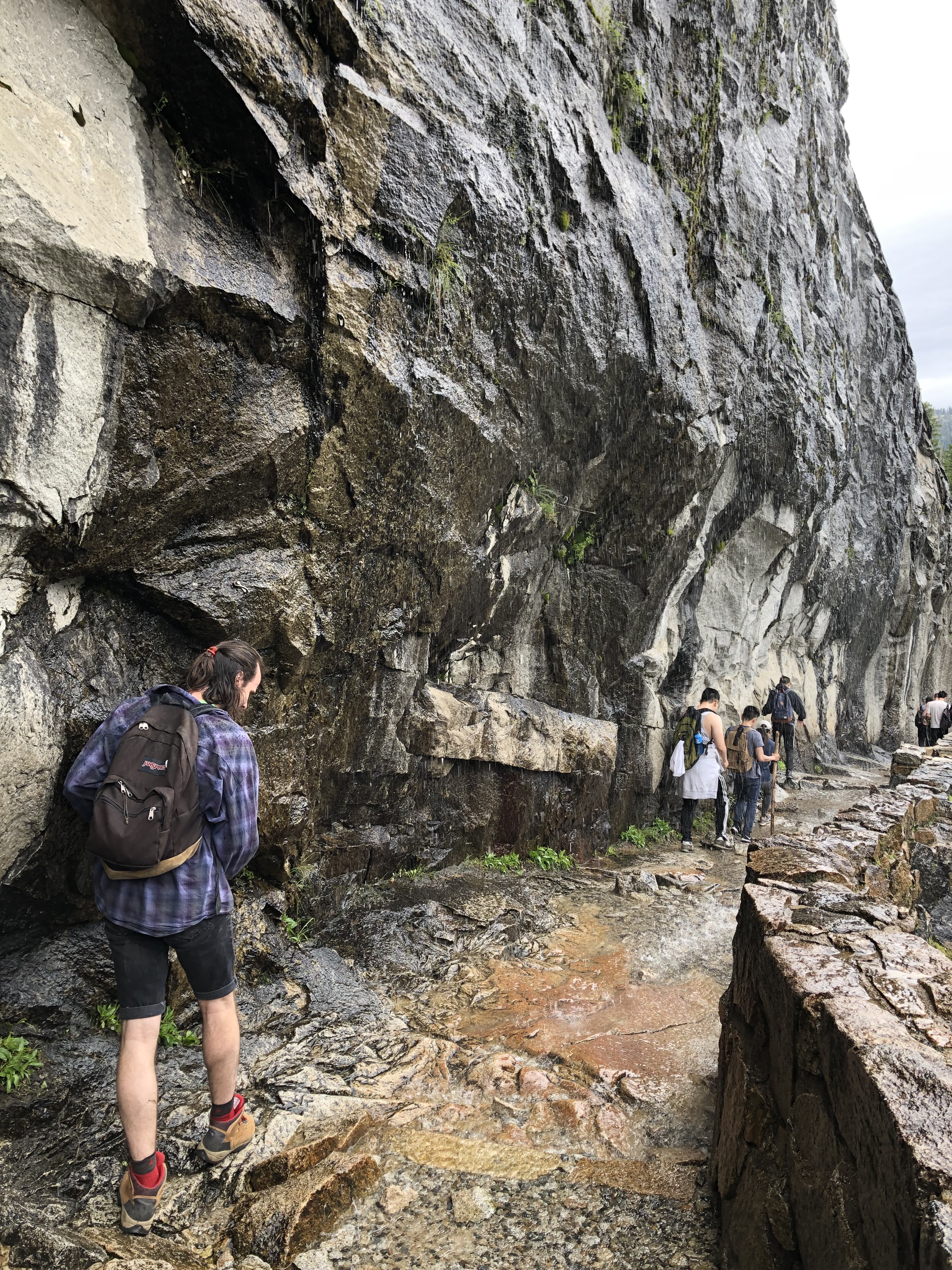
Venture a little further and you’ll split from the John Muir trail. Before entering the next stretch, make sure to pack away anything that could suffer from water damage. If you’re worried about getting wet, bring some waterproof gear as well. The misty section starts pretty suddenly, and the trail beneath you will get slippery in addition to mist bombarding your eyes. It may be uncomfortable, but you definitely don’t want to rush through this section. There’s usually a backup here on busy days, so you’ll be proceeding at the same pace as the “conga line” of hikers. Watch your footing, do your best not to step right in puddles, and definitely don’t get too close to the edge! One saving grace of this section is that it’s enforced as one way only, meaning that you won’t have to worry about anyone going down needing to pass you. Once you’re out of the mist, don’t stop right away. The remaining section to the top of the falls is steep without much room for passing, so proceed all the way up before packing away your waterproof gear or fetching your phone from your bag. You’ll be glad you did, the overlook above the falls itself is one of the best in the park, and is a welcome relief to relax at after the arduous climb up!
The falls overlook is to the right, with the bottom left engulfed by mist from the falls, giving this trail its nameThere’s a barrier set up apart from the river, but it doesn’t guard from the freezing river water completely!
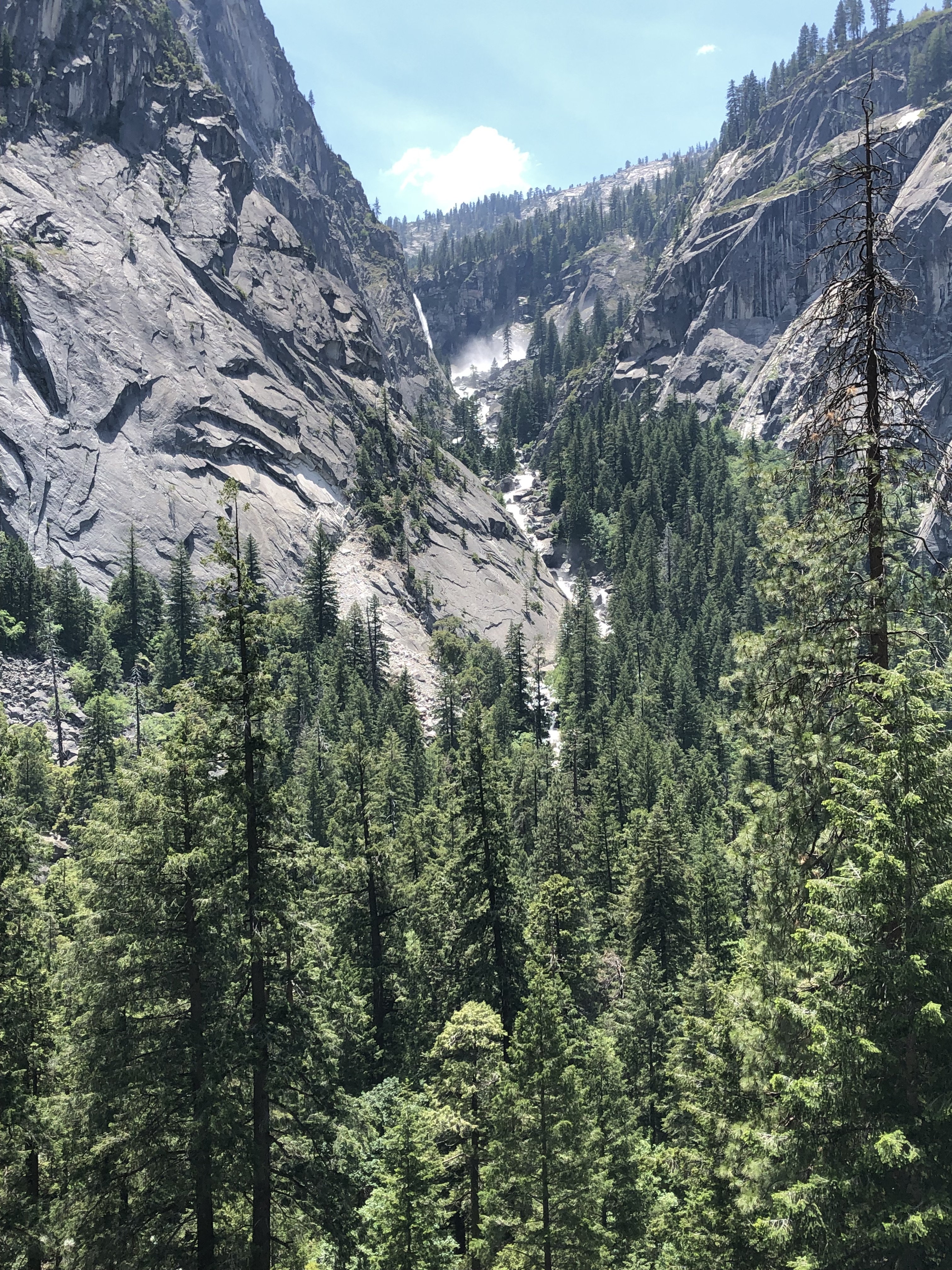
After taking some time to refuel and dry off, you have another decision ahead of you. You can either head up a little further and take the trail back down, or continue onwards to Nevada Falls. Those falls will be visible from the Vernal Falls overlook, and look pretty close. However, they are still quite a trek at 1.5 miles and more importantly, 600 feet of elevation away. My group only had enough time for this extension my second time on the trail, and even then we were pretty surprised at how hard this chunk turned out to be. If you have the time and stamina though, I’d absolutely recommend that you continue up. There are a couple smaller falls along the way, and some stunning theatrics that the river undergoes. There was one section where the rocky riverbed must have been uneven, and jettisoned wave after wave of spray downriver. Just like the waterfalls, this display really emphasizes the sheer power of running water. Also, I find it stunning just how accurately modern cameras, even on phones, manage to capture the intricacy of patterns that spray produces.
A beautiful surge of water, generated by some rocky outcropping on the riverbedOne of the shorter falls that the river tumbles down, between the Vernal and Nevada falls
Eventually, you’ll reach the top of Nevada Falls itself! This is my recommended turnaround point for day hikers, since this is the opportunity to make your trip into a loop, and the next destinations are quite a bit further up. There’s a large outcropping overlooking the Nevada Falls as well, which is a great place to rest up or eat something. From here, you have even better views of Liberty Cap, and the valley that the Merced River travels through. There’s no guardrail separating you from the river though, so you’ll need to be careful and not venture near the edge. It’s remarkable how calm and shallow the river is just upstream of the falls, where you can see the bottom clearly and the rocky river bottom casts the water in different colors. However, just ahead of the drop is a churning whirlpool of water, followed by the devastating drop of the falls. While Yosemite Falls gets the crown and fame for being the tallest waterfall in the park, I love this trail for how close you can get to observing both Vernal and Nevada falls, and the unique experience of hiking through the waves of mist generated by Vernal falls.
Nevada Falls with Liberty Cap watching over it, taken from further down the trailThe flow of the river is surprisingly calm up here, ahead of the Nevada FallsThe river crashing over its final steps to the falls, overlooking the valley that the Merced River has carved out
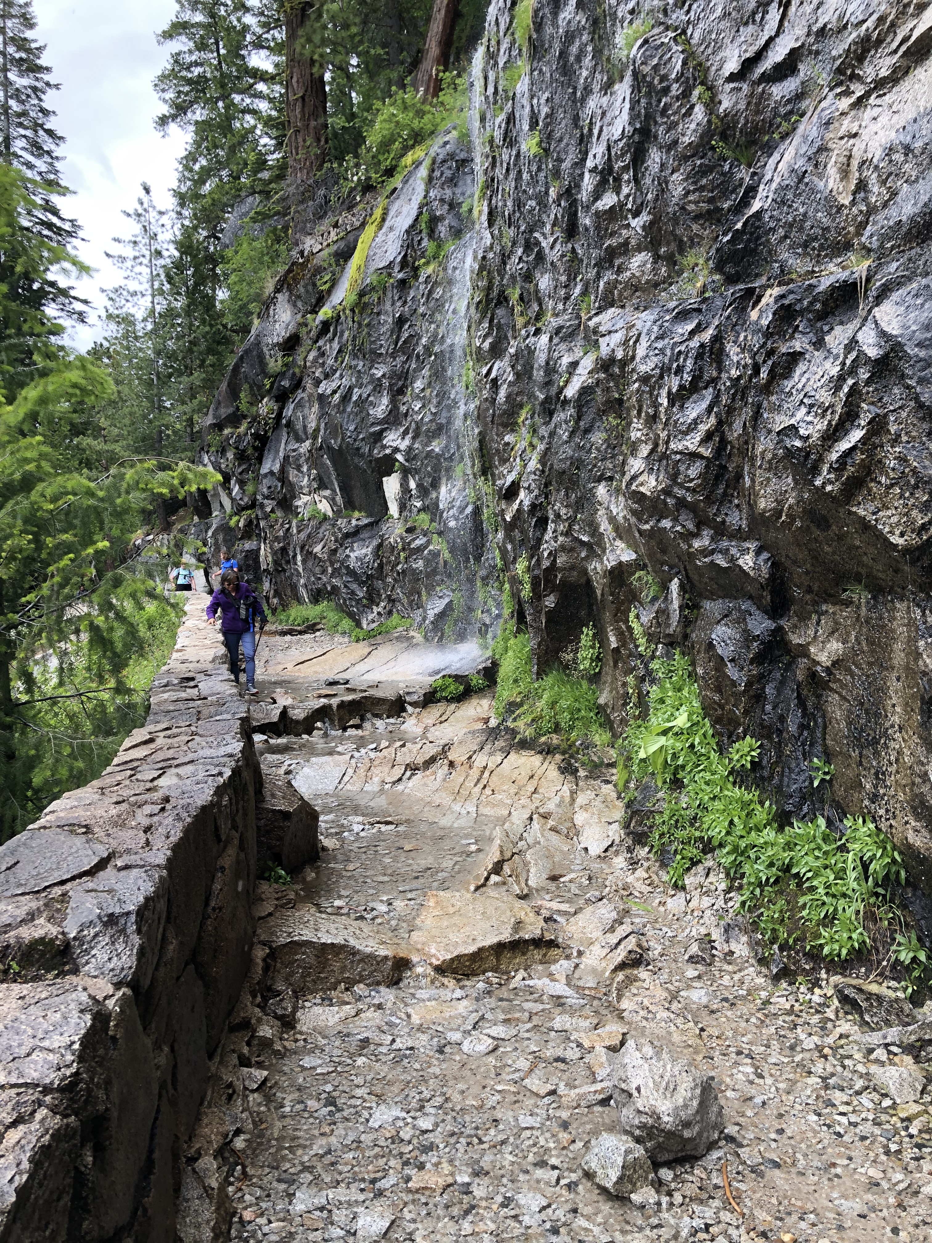
From Nevada Falls, you’ll likely be heading back downhill on the John Muir trail. The first section of this part is the most remarkable, as it features a “weeping wall” that you’ll hike under. You’ll want to secure anything that could be damaged by water, and break out your waterproof clothing again. Unfortunately, there isn’t a good section after this to sun yourself, so you’ll dry off slower than you did after the misty section of the trail. Most of the trail beyond this is a bunch of switchbacks, which will eventually land you at the Vernal Falls bridge and the Happy Isles parking lots and shuttle stops afterwards. This is where you’ll have your best chance to get faraway shots of the two falls, though. You’ll have many chances to photograph Nevada, and then Vernal falls as you descend on the switchbacks. Going down the trail is much faster than ascending it, and hopefully you won’t have that long of a walk or wait for the shuttle back to your car when you return.
Part of the “weeping wall” section of the John Muir trail, just after Nevada FallsYou can see places along the wall where water cascades down onto the trail’s hikers
So, that’s what my group’s experience on the Mist Trail was like, all the way up to Nevada Falls and back! It’s one of the most popular day hikes in the valley, so you’ll come across it easily when doing your own research on trails. It’s definitely a personal favorite of mine, and I wouldn’t hesitate to take someone here for their first trip into Yosemite Nat’l Park. The cases where I wouldn’t are if they are afraid of heights, or hate getting wet. You’ll also want to make sure your group has the stamina for some steep sections of trail, and about 6 miles of roundtrip hiking to Nevada Falls. And as I’ve said before, find a parking space ahead of the crowds! Conventional wisdom seems to be 9 a.m. or earlier on weekends for trailhead parking, while parking in the valley overall tends to fill between 10 a.m. and 11 a.m. Hopefully you’ll find this guide useful in deciding whether or not to pick this trail for your adventure into Yosemite, and getting an early enough start if you do.
Asiana A350-900 Flight from San Francisco to Seoul Incheon
Scheduled Departure: 11:30 p.m. on Wednesday, February 13th 2019
Scheduled Arrival: 5:30 a.m. on Friday, February 15th 2019
Flight Duration: 13 hours
Class of Service: Business
Asiana aircraft in the morning snowstorm at Seoul Incheon airport
By the time I’d finished dinner in the United Polaris lounge, my Asiana flight to Seoul had started boarding. The other priority passengers had finished boarding by the time I got to the gate, so I walked straight through the line and onboard Asiana’s new A350-900! It was my first time ever flying Asiana airlines, and I was certainly excited to be flying them in business class. This is especially true since the flight was a redeye, and getting sleep would be much easier because the seat could be converted into a flat bed. But I was interested to see how the rest of their service stacked up against other transpacific airlines, and how they tried to stand out from that crowd.
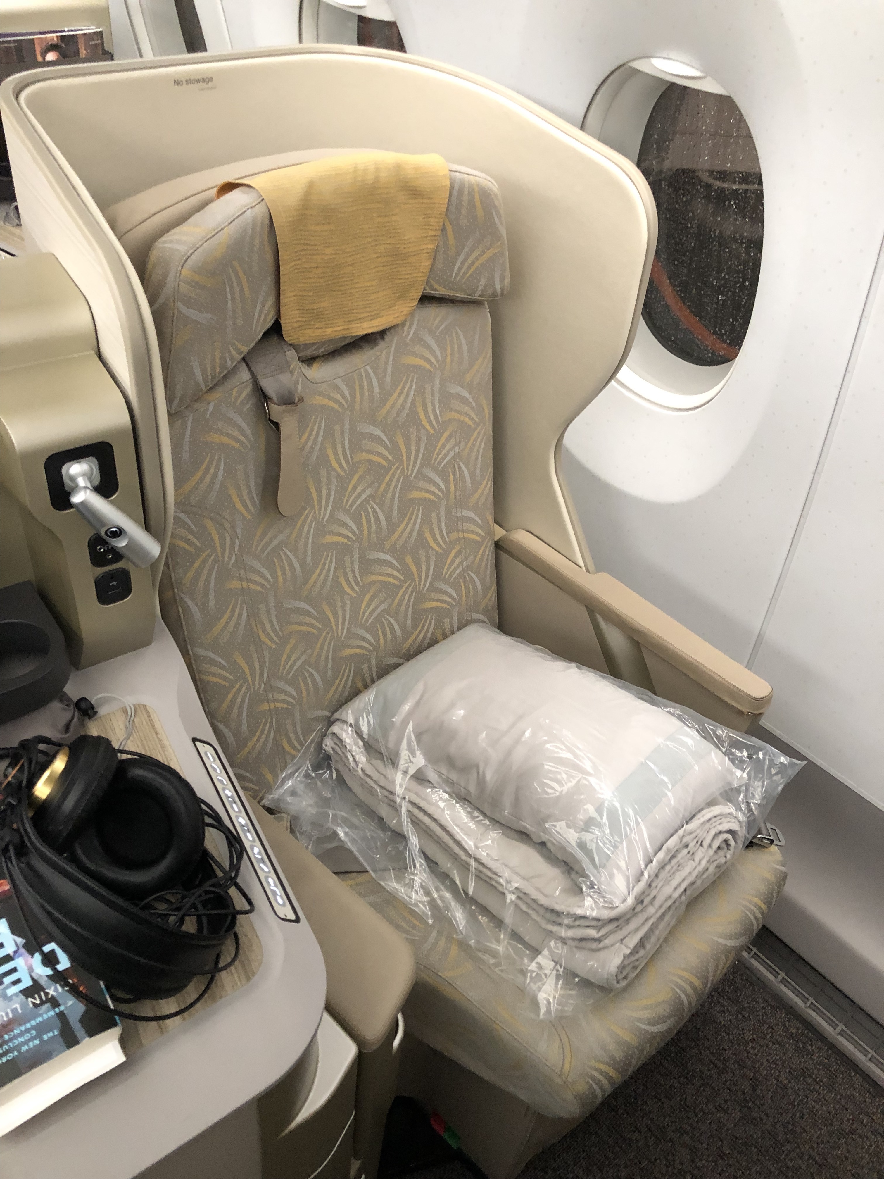
Let’s start with the cabin and the seat. The business class cabin on the A350 is relatively small, at 28 seats total. In order to conserve space, the seats are staggered so that they are alternatingly closer to or further from the aisle. Since I was traveling alone, I chose seat 4A on the lefthand window side, further from the aisle. The seat itself faces forward and is tucked up right against the window. The seat itself had more padding than an economy seat to be more comfortable, but didn’t have any special plushness or texture. Because of the privacy shield I had to lean forward a bit to get clear views out of my windows, but this was fine by me. To my right was a countertop that I used to store my book and headphones, among other things during the flight. It also created a buffer between me and the aisle, while for a seat against the aisle that countertop would be nestled against the window. If I’d had a traveling companion, we could have selected a pair of seats in the center that are adjacent to each other. The fixed privacy shield for those seats doesn’t extend out far enough to prevent us from looking at each other and we could hold hands together either on the armrest or in front of it. Because the configuration still needs to be able to provide privacy if the two people in these “couple seats” are strangers, they’re not perfectly intimate but they’re good enough. Each seat also has a high resolution screen straight ahead of the seat, making it easy to focus on if need be. Below it is an ottoman that the seat extends to when it’s flattened into a bed, but can also be a place for propping up feet or for storing things. So while the seat is not the most stylish I’ve seen, it served all the basic functionality I needed quite well. My takeaway is that it’s the most businesslike of the business class I’ve traveled in.
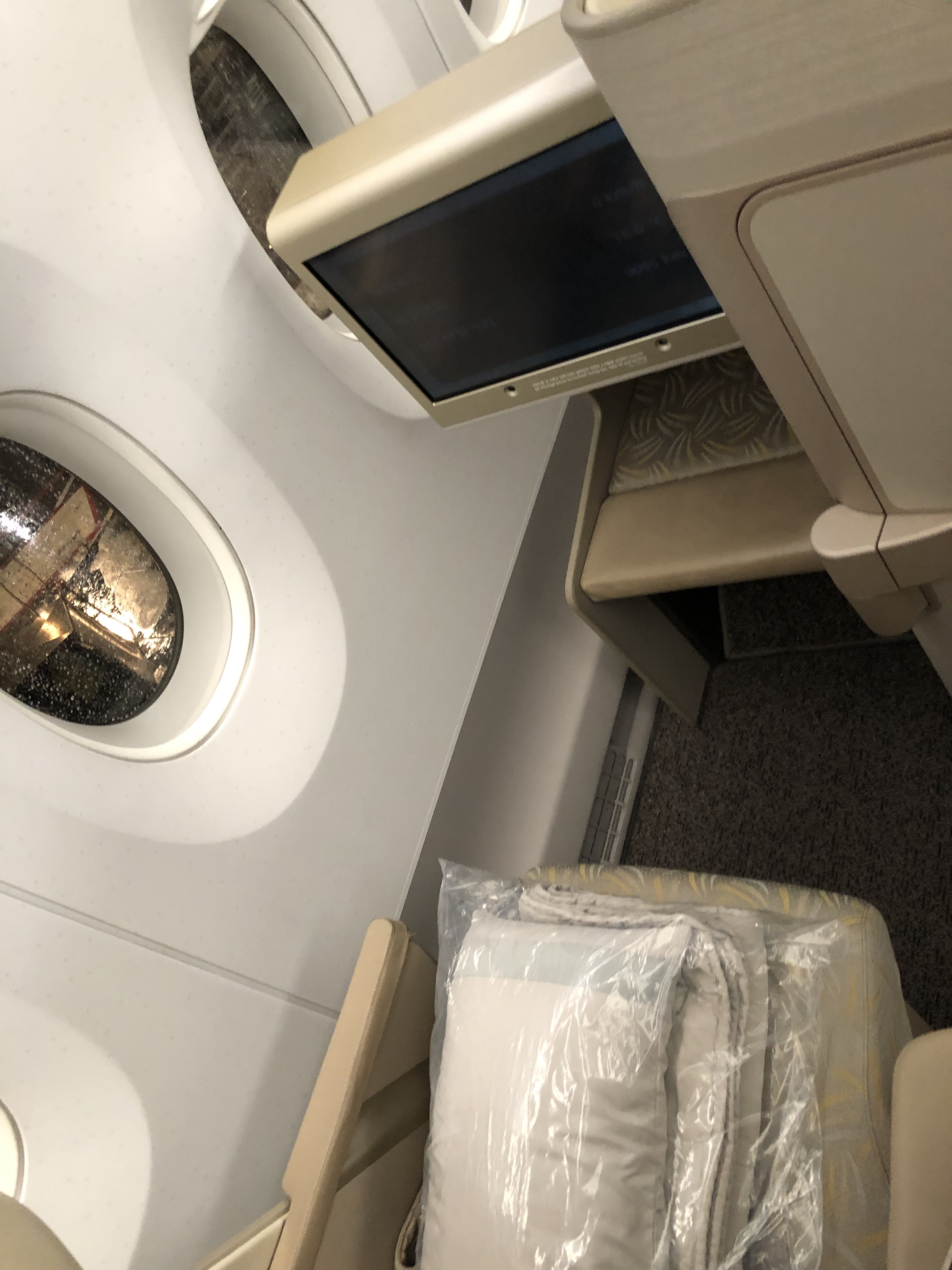
My seat nestled against the window. It offers more privacy than the other window seats A window seat that is actually against the aisle. Less privacy and accessability to its windows A pair of “couple seats” that are closer to one another than they are to the aisle My entertainment screen and the ottoman below it. A comfortable and spacious enough setup My storage countertop, with charging ports and a light close to me.
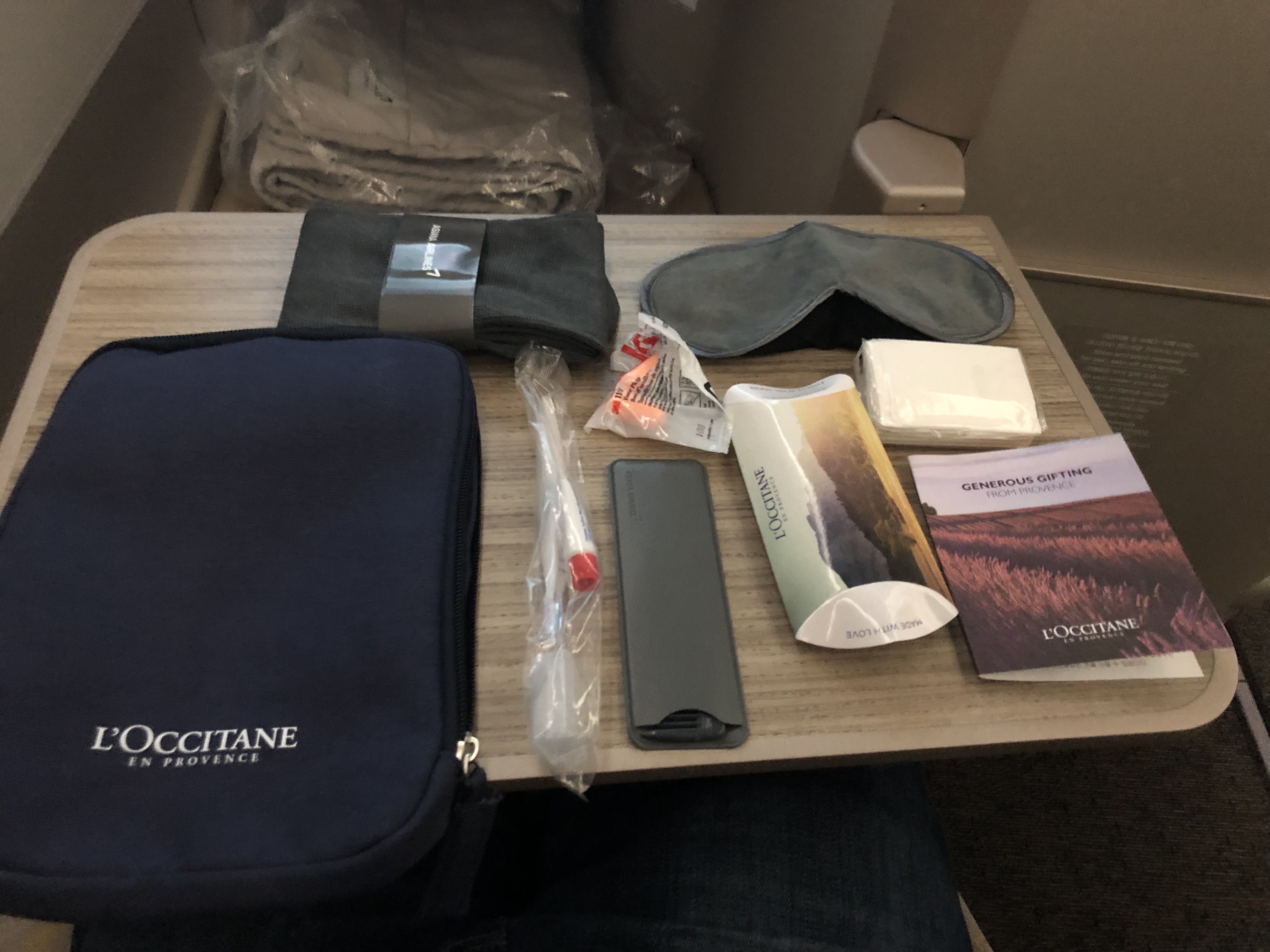
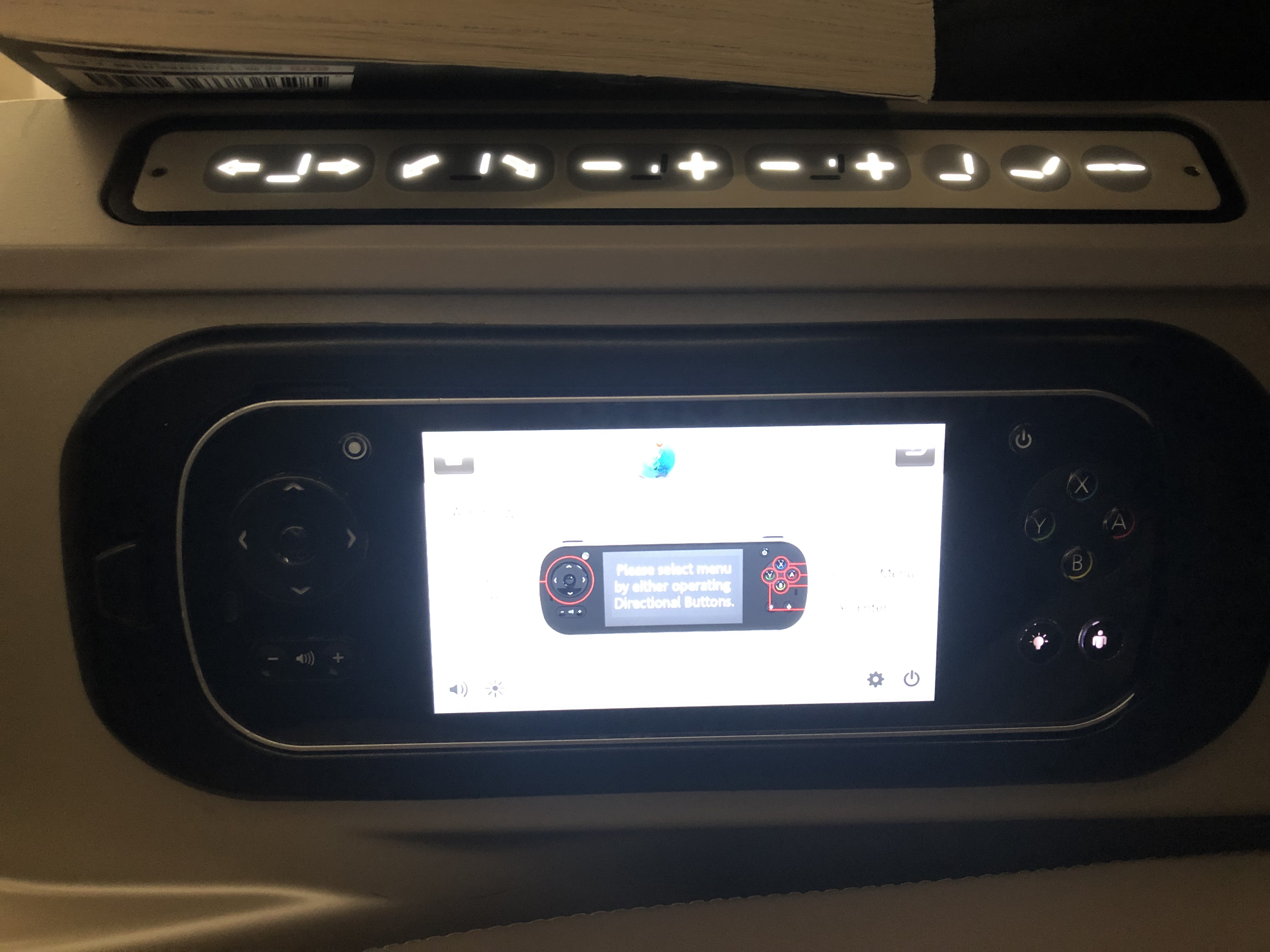
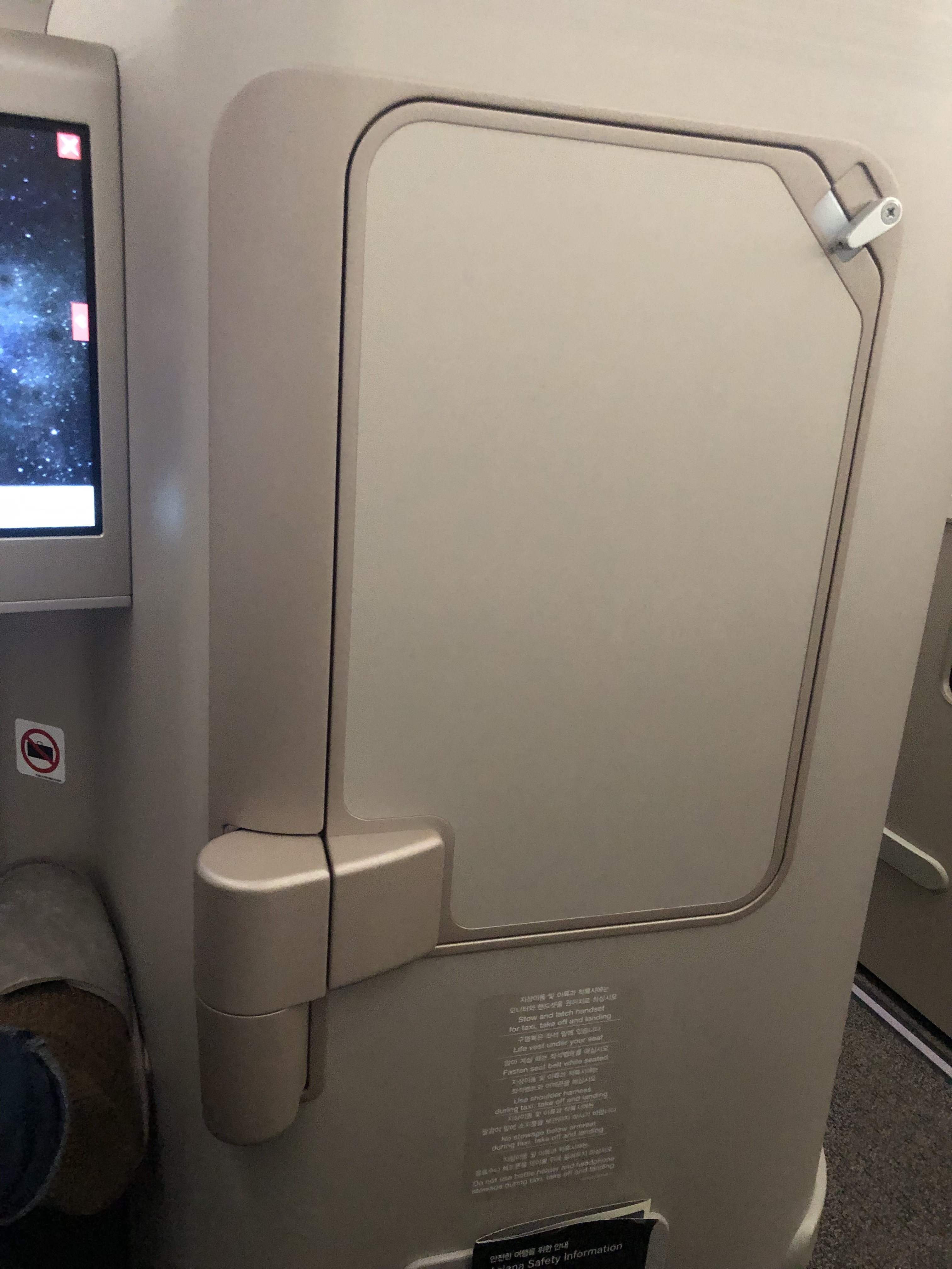
Going into the seat details a little more, most of the features that you’ll use are between the seat itself and the countertop. The top panel features the seat controls, which are used to move the seat to recline or stretch fully into bed mode. Below that is a handheld console for the entertainment screen, since it’s too far away to reach comfortably. Up on the wall is an adjustable light which is helpful for reading a book or the menu, with headphone jacks and a USB charging port below it. Further away is a cupholder, which is where my amenity kit was placed when I got to my seat. The kit was from L’Occitane, and was a flimsy, scratchy pouch. Its innards didn’t redeem it, it had mostly just the bare essentials and low quality ones at that. I unfortunately had forgotten my personal eyemask though, so the one they provided came in clutch on this flight. Lastly, the tray table was cleverly locked against a panel in front of my seat’s countertop, making it easy to operate on my own.
The disappointing amenity kit, save the eyeshades. I didn’t want to keep that pouch afterwards The seat controls on the top, and entertainment screen controls on the bottom Clever way to keep the tray table outta the way!
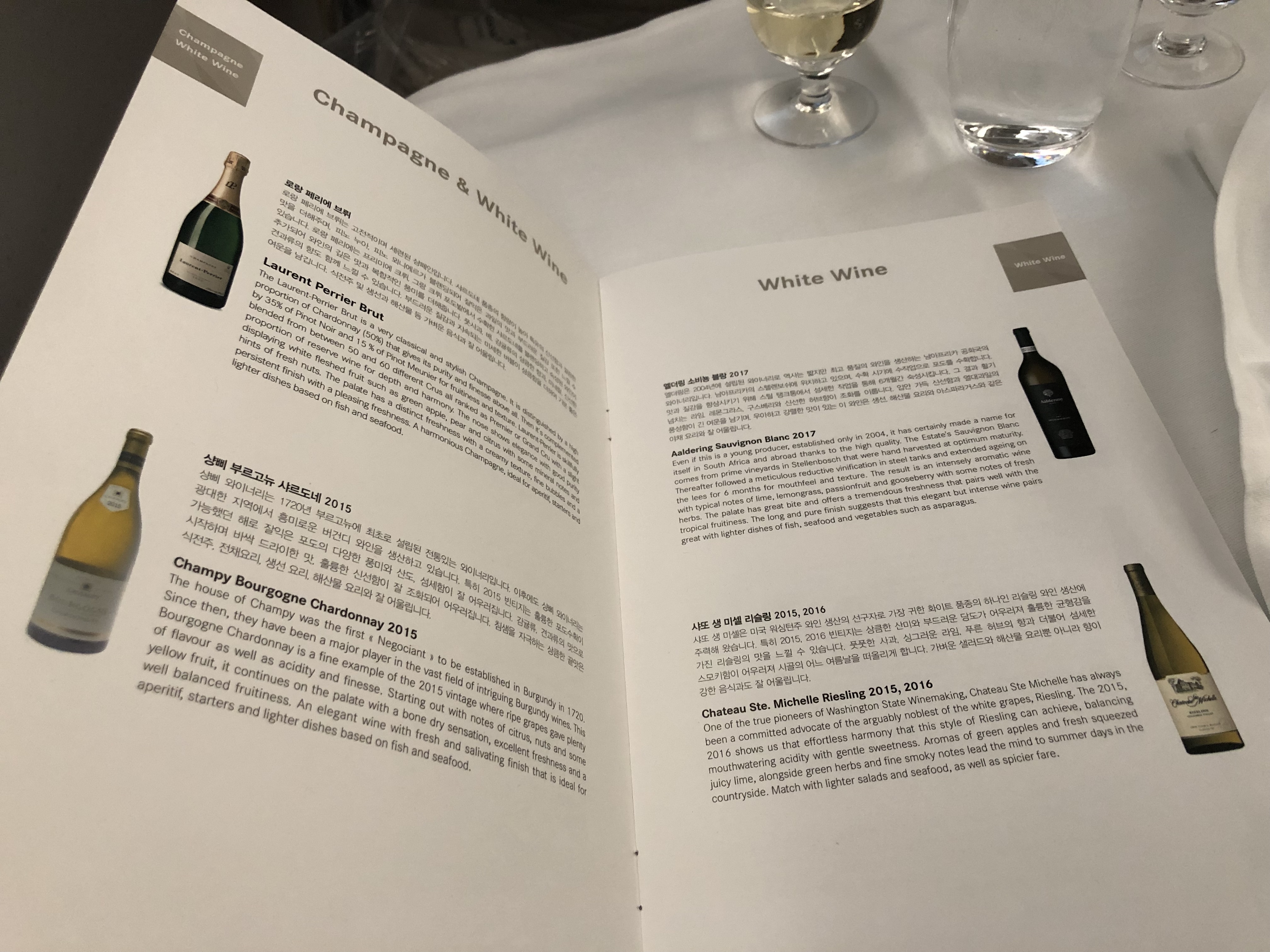
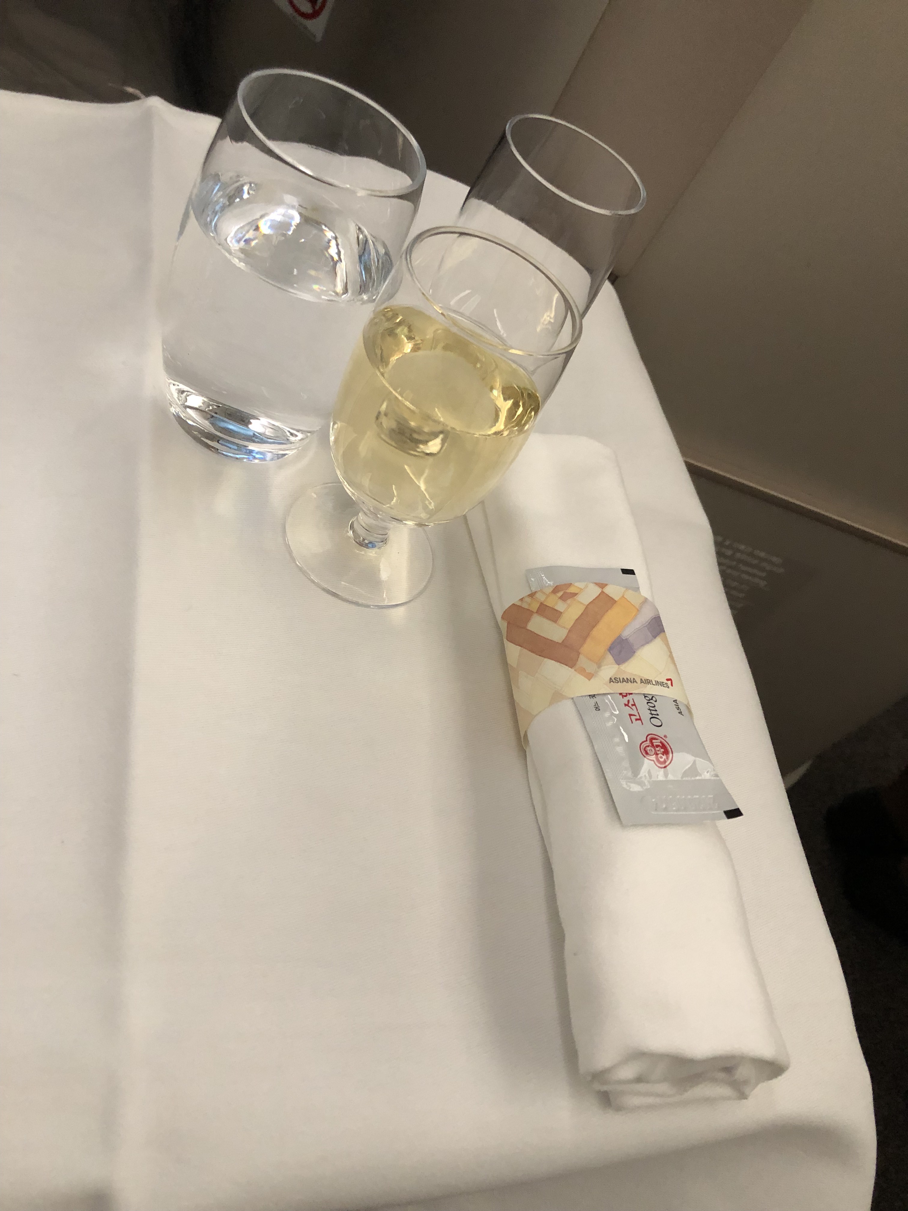
This may be surprising to many, but between eastbound transcontinental redeyes and westbound redeyes to Asia, SFO actually has a glut of flights departing between 11 p.m. and 1 a.m. each night. This meant my aircraft had to queue up on the taxiiway, and we didn’t get airbourne until slightly after midnight. That was fine by me, since it put more time between my 10:30 p.m. dinner in the Polaris lounge and my onboard meal. My flight’s dinner service got started pretty quickly, with the first round of drinks being offered about a half hour after takeoff at 12:30 a.m. local time. I selected champagne as always, which was Laurent Perrier today. The menu itself is fairly compact, typically with one Korean option and two or three International ones. Tonight the Korean option was bibimbap, which looked like the most healthy choice ahead of my half marathon. I also perused the wine list so that I’d be ready with my pairing choices when I was asked for them.
It seems I only got a picture of the Korean page of the menu. I was really tired… Thankfully, the languages are together on the important part: the wine list! A glass of champagne to start off, accompanied by the healthier choice of water
The appetizer was pretty tame. It consisted of a couple chilled rolls of roast beef, with sprouts and radishes tucked inside. There was also a stray tomato with some dressing. Honestly, I’m drawn more to the beauty of the plate than the goodness of that appetizer. They were unmemorable and gone in a few bites. Next was the bibimbap, which is a staple as the Korean option on most Asiana flights. There were fewer side dishes than normal so that there’d be enough space to keep them on the tray table, with only kimchi, anchovies, and spicy paste making the cut. The rice was pretty dry and crumbly, which was a bit of a disappointment for the dish. The vegetables were a little soggy but not enough to make the dish unpleasant. And the spicy paste helped to cover them up anyway. The seaweed soup on the side was hearty, and helpful at dispelling the spicyness of the paste that I used. The meal was good and healthy, but it isn’t something that would cost more than $10 at most restaurants and doesn’t have much of a premium feel to it, save the beautiful dishes. I downed a glass of the South African sauvingnon blanc with this one. Dessert was simple, a packaged savory ricecracker and a raspberry tart. If I had to pick a best part of this unremarkable meal, it would be the tart. The Riesling I chose to go with them was sweet and delicious, too. The meal was pretty quick, and I was able to start getting ready to sleep by about 1:30 a.m., just 90 minutes after takeoff.
A quick roast beef appetizer. Can we talk about how elegant that plate is? Asiana’s bibimbap setup. Most of the ingredients could be fresher Raspberry tart, rice cracker, and riesling off to the side. A quick but unremarkable meal
For sleeping, Asiana only provides a pillow and a plush blanket. The pillow is pretty small, and doesn’t quite cover the width of the seat. It was warm enough in the cabin that I didn’t need the blanket, so I laid it over my seat once I’d flattened it and slept on top of it. There’s enough space to move around so that I didn’t bump against anything while moving around to get comfortable. I went to sleep just hoping that I’d stay that way for awhile. And thankfully, I did! I didn’t wake up until about 2 hours before landing, which meant I had slept for nearly 9 straight hours! Since the breakfast service was due to start soon, I’d slept almost the entire length in between and maxed out the sleeping value of the flight! I know some travelers, especially those who use miles like I usually do, forego some sleep so that they can dedicate more time to enjoying the experience. But after the meal service, the only things to really do are reading, watching a movie on the entertainment screen, or purchasing the wifi and hopping on. None of those are nearly as important as sleep on a redeye, in my opinion. I’d much rather be awake for only 4 of the 13 hours and arrive well rested and energized, than stay up to enjoy more of the flight but be exhausted at my destination in return.
My seat in bed mode, with the blanket tossed to the side. Bare bones, but it worked for me!
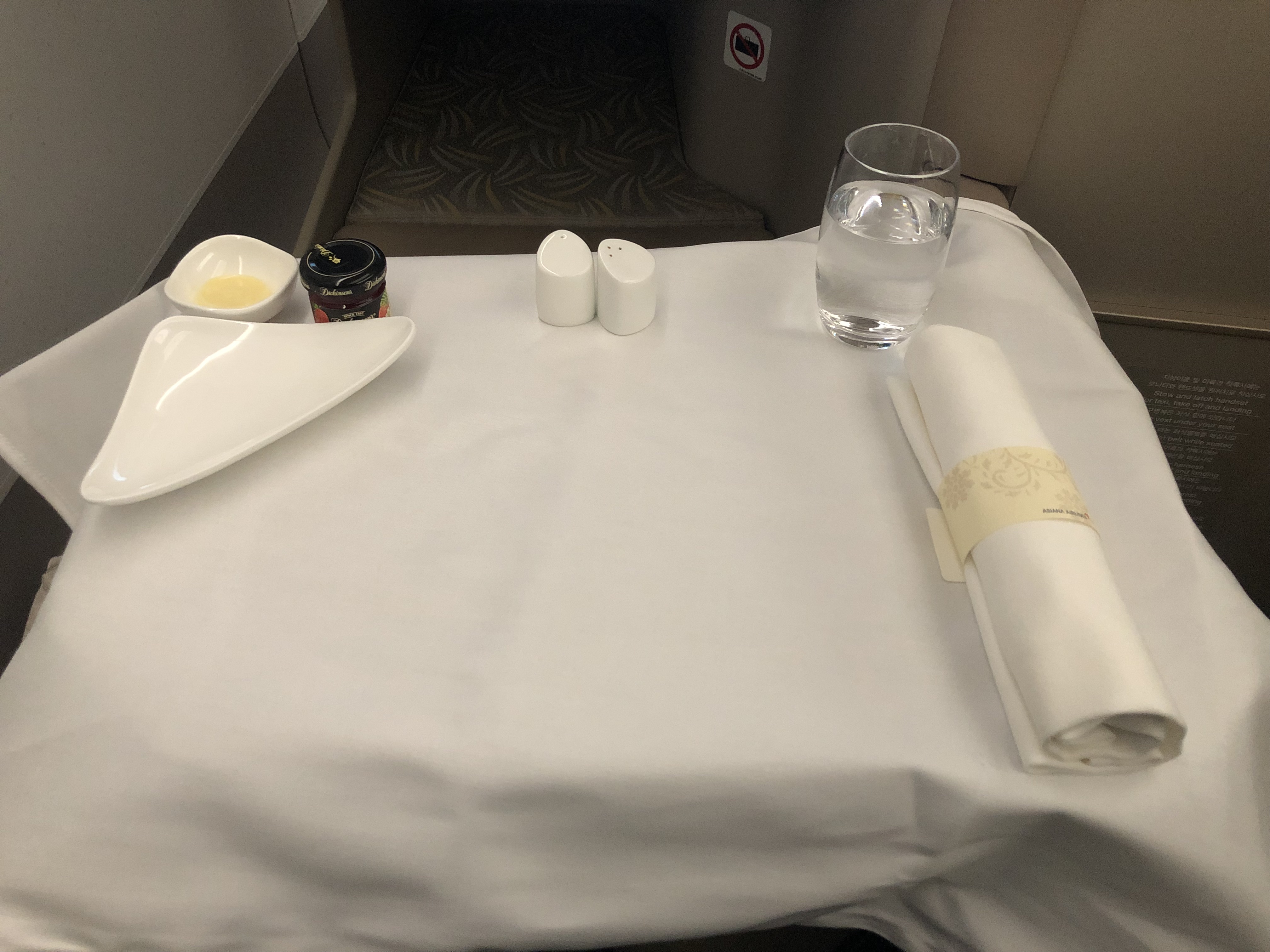
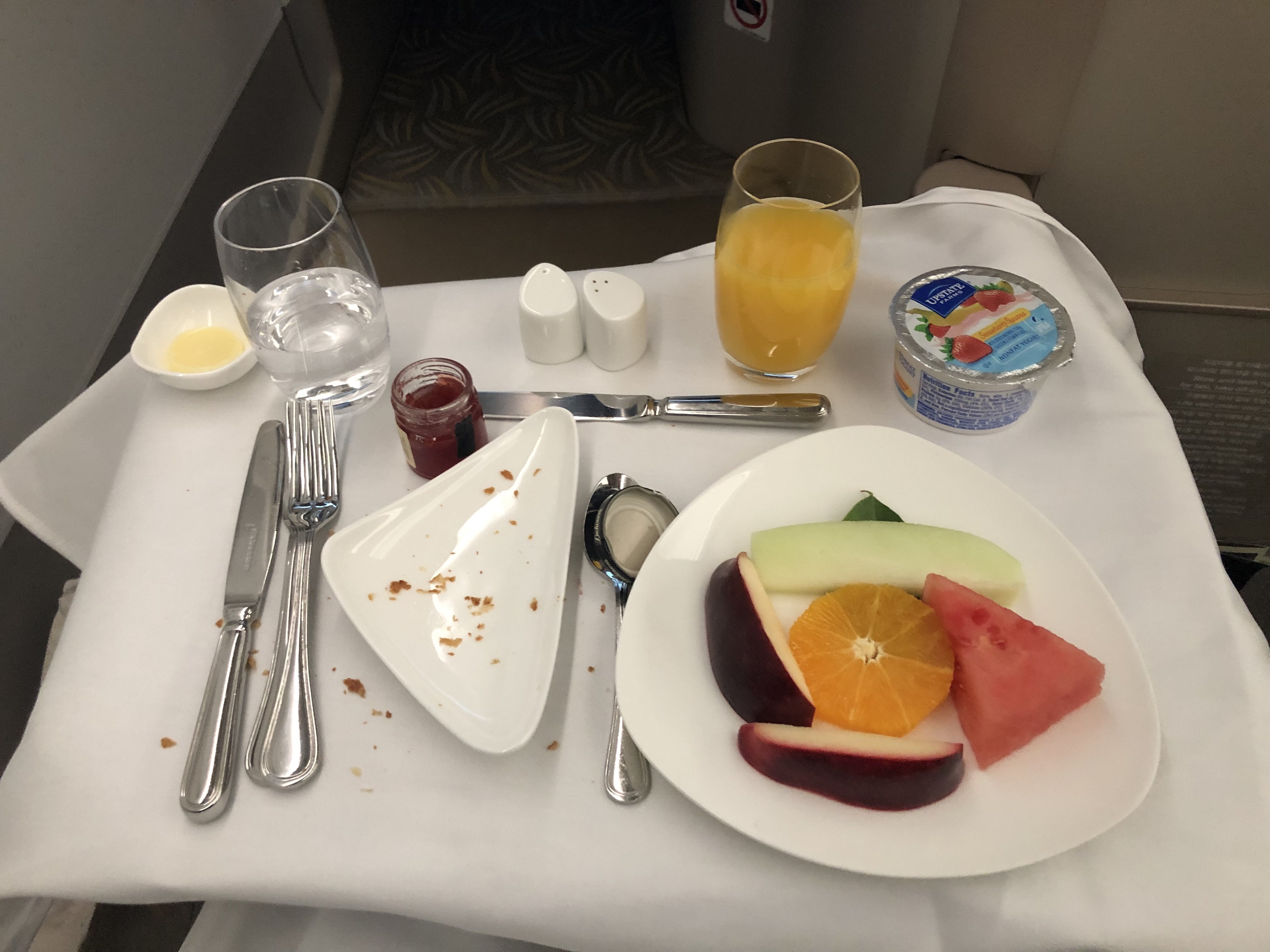
A flight attendant came by after I looked fully awake and offered to start the breakfast service, which I was happy to do. Like dinner, breakfast was a relatively simple affair. I started with water, orange juice, and a glass of Earl Grey to start. The first part was a fruit plate, yogurt, and a warm croissant that I was too excited to eat before taking a picture. Strawberry jam and butter were available for the croissant too. I followed it up with the breakfast platter, which consisted of bacon, mushy eggs, a boiled tomato, and blueberry pancakes slathered in blueberry sauce. I just ate the tomato and pancakes, but the pancakes hadn’t gone soggy and the sauce was rich and flavorful. I also used the last of my butter and jam to cover any surfaces that the blueberry sauce wasn’t enough for. Despite being about as simple as the dinner, the parts I ate were kept fresh a lot better than the dinner ingredients.
Table setting for breakfast before any of the food comes Round 1, the fruit setting, yogurt, juice, and flakes from a vanished croissant! Round 2, the lovely pancakes and not great looking everything else
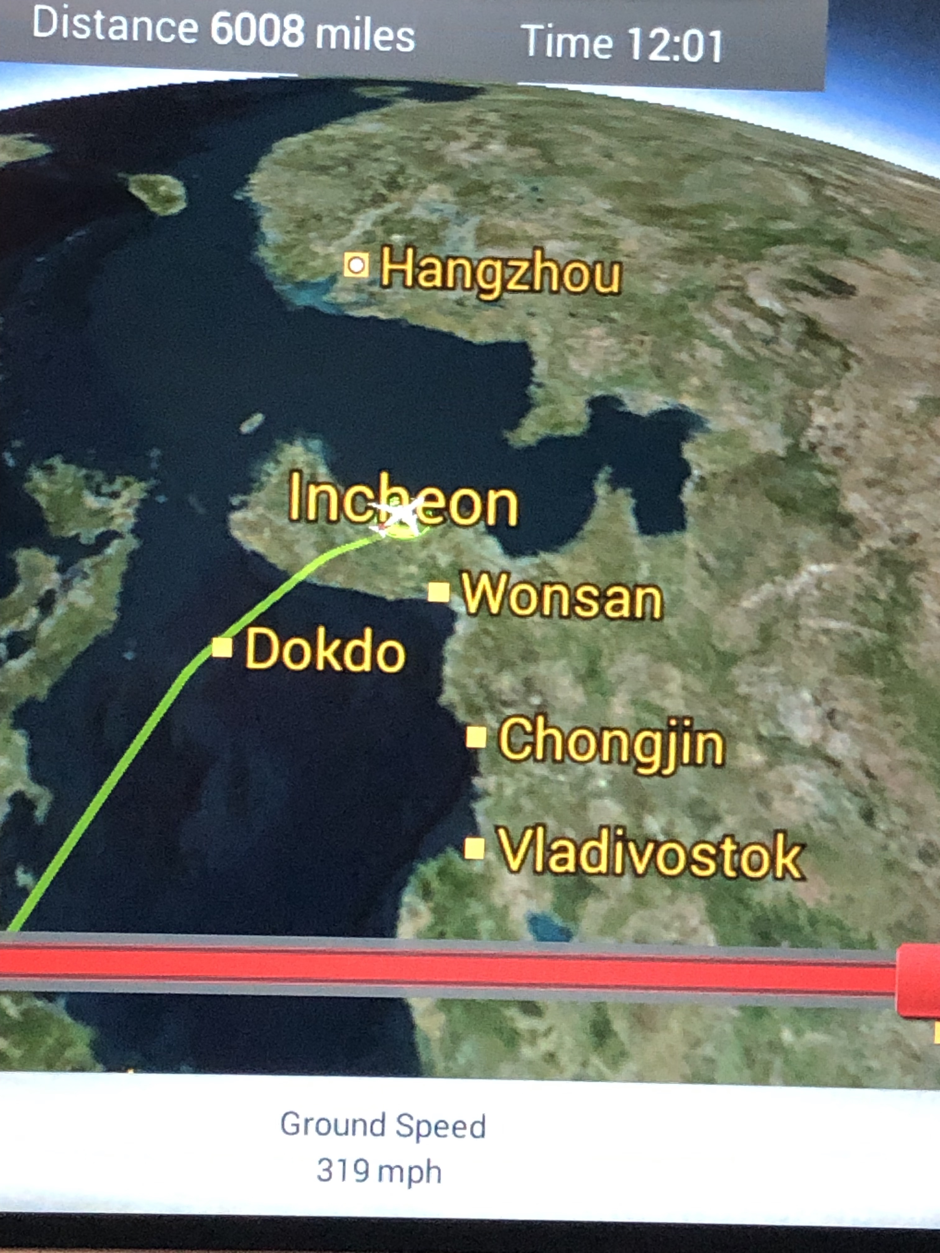
There was just under an hour left to Seoul after I finished eating, so I spent the rest of the flight flicking through the entertaiment selection and deciding what I might watch on my connecting flight to Hong Kong. After that I swapped to the infilght map, which is what I default to looking at if I don’t feel like or have enough time to watch a movie. As a last interesting feature of the flight, I noticed the inflight map made some interesting choices about what to include. Wonsan, a North Korean city, features on the map. So does Dokdo, which you might notice is an island midway between Korea and Japan. That it’s included above larger cities of say, Busan or Daegu, may be strange to an average joe but makes a lot of sense to any Korean citizen. I’ll leave its backstory for the reader to research themselves…
Despite its small size, Dokdo features prominently on Asiana’s inflight map
Let’s wrap up by going over the important points of the Asiana business class experience. Between the excellent rest I got, simple but filling meals, and practical but boring layout and coloring scheme of the seats, Asiana strikes me as being the best business class for a passenger who only cares about the functionality of the experience. If you’re looking for a meal on either side of a full night of sleep for convenience, leaving time to have productive work and meetings on the days on either side of this flight, Asiana’s product hits on everything you need. But for someone hoping for a special or memorable experience, particularly couples or honeymooners traveling for fun, I would recommend another option if it’s available. The inflght experience, food, or comfort of my experience wasn’t above average for business class in any category, but nothing was sorely lacking either. So I think it would be a letdown for anyone looking for something special, while its normalcy is well suited for regular business travelers. If they were my only option I would’t hesitate to fly Asiana again in business class, but I’d even prefer a one-stop routing on EVA Air or ANA to a nonstop on Asiana given the choice.